Scandiano night lights from space
Night Light of Scandiano (Emilia-Romagna) from space (Italy) Src. Average luminocity for 10x10km area is 45.0409% and for 50x50km: 33.516%.
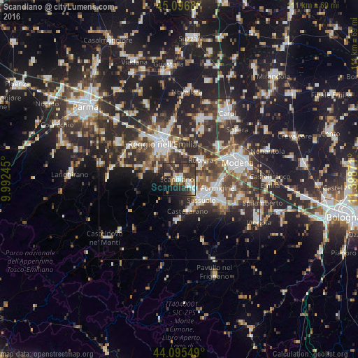
Analysis of Scandiano night lights 2016
Square area 10x10 km:
 5.3%
5.3%90-99
8.48%80-89
5.61%70-79
4.24%60-69
5.3%50-59
5.61%40-49
8.79%30-39
16.82%20-29
20.91%10-19
14.7%0-9
4.24%Square area 50x50 km:
5.66%90-99
7.03%80-89
3.08%70-79
2.8%60-69
3.62%50-59
4.61%40-49
6.3%30-39
8%20-29
14.72%10-19
11.66%0-9
32.52%Clear (daylight) street map image can be seen on geolist.org.
Map coordinates:
45° 5' 48.5" North, 9° 59' 32.8" East
44° 35' 53.9" North, 10° 41' 44.1" East
44° 5' 43.8" North, 11° 23' 55.4" East
Some cities around Scandiano sort by population:
• Reggio nell'Emilia
12.2 km =7.6 mi,  335°
335°
• Sassuolo
9.4 km =5.8 mi,  130°
130°
• Formigine
12.4 km =7.7 mi,  103°
103°
• Fiorano
11.3 km =7 mi, 125°
• Rubiera
8.9 km =5.5 mi,  48°
48°
• Castellarano
9.5 km =5.9 mi,  159°
159°
• Casalgrande
3.5 km =2.2 mi,  115°
115°
• Veggia-Villalunga
6.4 km =4 mi, 131°
3166989 (p: 11,010)
Sources (retrieved 2019-11-25):
» Earth at Night: Flat Maps 2012, 2016