Sala night lights from space
Night Light of Sala (Campania) from space (Italy) Src. Average luminocity for 10x10km area is 33.4405% and for 50x50km: 33.3064%.
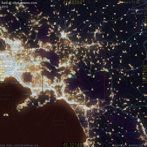
Analysis of Sala night lights 2016
Square area 10x10 km:
 2.38%
2.38%90-99
4.76%80-89
6.63%70-79
3.91%60-69
4.76%50-59
4.42%40-49
5.27%30-39
5.27%20-29
17.01%10-19
21.09%0-9
24.49%Square area 50x50 km:
3.57%90-99
5.85%80-89
3.96%70-79
3.62%60-69
4.52%50-59
6.04%40-49
5.44%30-39
7.96%20-29
13.69%10-19
17.25%0-9
28.1%Clear (daylight) street map image can be seen on geolist.org.
Map coordinates:
41° 23' 6.1" North, 14° 10' 13.1" East
40° 51' 19.3" North, 14° 52' 24.3" East
40° 19' 17.1" North, 15° 34' 35.6" East
Some cities around Sala sort by population:
• Avellino
9.6 km =6 mi,  313°
313°
• Solofra
3.9 km =2.4 mi,  231°
231°
• Monteforte Irpino
12.1 km =7.5 mi,  295°
295°
• Atripalda
8 km =5 mi,  331°
331°
• Montoro Superiore
7.6 km =4.7 mi,  235°
235°
• Montella
12.2 km =7.6 mi,  96°
96°
• Serino
0.1 km =0.1 mi, 238°
• Lancusi-Penta-Bolano
12.8 km =8 mi,  215°
215°
8948764 (p: 6,237)
Sources (retrieved 2019-11-25):
» Earth at Night: Flat Maps 2012, 2016