Montella night lights from space
Night Light of Montella (Campania) from space (Italy) Src. Average luminocity for 10x10km area is 6.9014% and for 50x50km: 25.2215%.
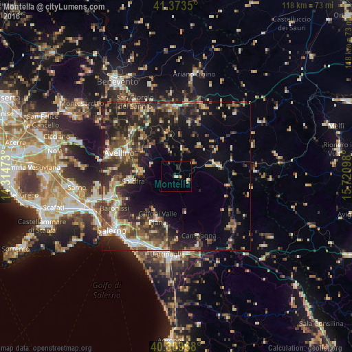
Analysis of Montella night lights 2016
Square area 10x10 km:
 0%
0%90-99
1.36%80-89
2.04%70-79
0%60-69
0.68%50-59
0.68%40-49
0.68%30-39
0.51%20-29
2.89%10-19
1.36%0-9
89.8%Square area 50x50 km:
2.24%90-99
3.82%80-89
2.97%70-79
2.72%60-69
3.16%50-59
5.17%40-49
4.44%30-39
6.32%20-29
10.11%10-19
11.87%0-9
47.16%Clear (daylight) street map image can be seen on geolist.org.
Map coordinates:
41° 22' 24.6" North, 14° 18' 53" East
40° 50' 37.4" North, 15° 1' 4.3" East
40° 18' 34.8" North, 15° 43' 15.5" East
Some cities around Montella sort by population:
• Avellino
20.6 km =12.8 mi,  292°
292°
• Solofra
15.3 km =9.5 mi,  265°
265°
• Giffoni Valle Piana
15.3 km =9.5 mi,  204°
204°
• Atripalda
18.1 km =11.2 mi,  297°
297°
• Mercato
15.6 km =9.7 mi, 204°
• Montoro Superiore
18.7 km =11.6 mi,  260°
260°
• Serino
12.3 km =7.6 mi,  275°
275°
• Sala
12.2 km =7.6 mi, 276°
6535638 (p: 7,199)
Sources (retrieved 2019-11-25):
» Earth at Night: Flat Maps 2012, 2016