Lancusi-Penta-Bolano night lights from space
Night Light of Lancusi-Penta-Bolano (Campania) from space (Italy) Src. Average luminocity for 10x10km area is 54.1299% and for 50x50km: 36.8225%.
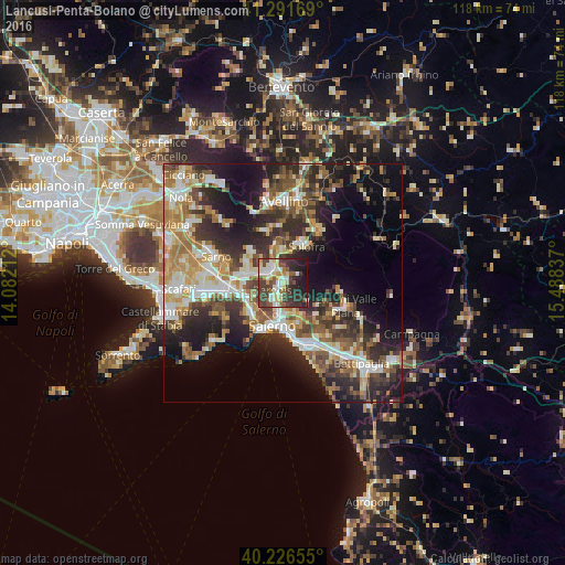
Analysis of Lancusi-Penta-Bolano night lights 2016
Square area 10x10 km:
 8.77%
8.77%90-99
13.31%80-89
5.84%70-79
6.33%60-69
2.92%50-59
7.95%40-49
13.31%30-39
15.1%20-29
16.23%10-19
10.23%0-9
0%Square area 50x50 km:
5.05%90-99
7.45%80-89
4.36%70-79
4.84%60-69
5.93%50-59
5.89%40-49
5.37%30-39
7.04%20-29
11.32%10-19
13.48%0-9
29.26%Clear (daylight) street map image can be seen on geolist.org.
Map coordinates:
41° 17' 30.1" North, 14° 4' 55.6" East
40° 45' 40.5" North, 14° 47' 6.9" East
40° 13' 35.6" North, 15° 29' 18.1" East
Some cities around Lancusi-Penta-Bolano sort by population:
• Baronissi
1.7 km =1.1 mi,  213°
213°
• Solofra
9.1 km =5.7 mi,  28°
28°
• Mercato San Severino
3.7 km =2.3 mi,  314°
314°
• Siano
9 km =5.6 mi,  300°
300°
• Montoro Superiore
6.3 km =3.9 mi,  10°
10°
• Castel San Giorgio
7.5 km =4.7 mi,  287°
287°
• Roccapiemonte
7.9 km =4.9 mi,  269°
269°
• Piazza del Galdo-Sant'Angelo
5.9 km =3.7 mi,  283°
283°
8948771 (p: 5,839)
Sources (retrieved 2019-11-25):
» Earth at Night: Flat Maps 2012, 2016