Montoro Superiore night lights from space
Night Light of Montoro Superiore (Campania) from space (Italy) Src. Average luminocity for 10x10km area is 51.5085% and for 50x50km: 38.472%.
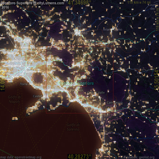
Analysis of Montoro Superiore night lights 2016
Square area 10x10 km:
 5.61%
5.61%90-99
12.24%80-89
7.65%70-79
4.93%60-69
8.84%50-59
5.95%40-49
6.97%30-39
14.12%20-29
21.6%10-19
11.05%0-9
1.02%Square area 50x50 km:
4.91%90-99
7.57%80-89
4.67%70-79
4.51%60-69
6.15%50-59
6.24%40-49
5.51%30-39
7.69%20-29
13.97%10-19
16.34%0-9
22.43%Clear (daylight) street map image can be seen on geolist.org.
Map coordinates:
41° 20' 49.1" North, 14° 5' 43" East
40° 49' 1.2" North, 14° 47' 54.3" East
40° 16' 57.8" North, 15° 30' 5.5" East
Some cities around Montoro Superiore sort by population:
• Baronissi
7.9 km =4.9 mi,  195°
195°
• Solofra
3.7 km =2.3 mi,  60°
60°
• Mercato San Severino
5.2 km =3.2 mi,  226°
226°
• Serino
7.5 km =4.7 mi, 55°
• Sala
7.6 km =4.7 mi, 55°
• Lancusi-Penta-Bolano
6.3 km =3.9 mi,  190°
190°
• Piazza del Galdo-Sant'Angelo
8.4 km =5.2 mi,  235°
235°
• Bracigliano
7.6 km =4.7 mi,  271°
271°
6534231 (p: 8,054)
Sources (retrieved 2019-11-25):
» Earth at Night: Flat Maps 2012, 2016