Civita Castellana night lights from space
Night Light of Civita Castellana (Latium) from space (Italy) Src. Average luminocity for 10x10km area is 18.0985% and for 50x50km: 14.5352%.
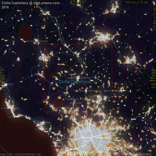
Analysis of Civita Castellana night lights 2016
Square area 10x10 km:
 0.45%
0.45%90-99
1.36%80-89
4.09%70-79
3.79%60-69
1.97%50-59
3.18%40-49
1.21%30-39
1.06%20-29
3.48%10-19
10.3%0-9
69.09%Square area 50x50 km:
0.86%90-99
1.92%80-89
1.58%70-79
1.57%60-69
1.7%50-59
2.41%40-49
1.98%30-39
2.46%20-29
4.44%10-19
10.19%0-9
70.9%Clear (daylight) street map image can be seen on geolist.org.
Map coordinates:
42° 48' 39.6" North, 11° 42' 20.6" East
42° 17' 34.9" North, 12° 24' 31.9" East
41° 46' 14.8" North, 13° 6' 43.1" East
Some cities around Civita Castellana sort by population:
• Ronciglione
16 km =9.9 mi,  268°
268°
• Campagnano di Roma
17.7 km =11 mi,  189°
189°
• Rignano Flaminio
11.4 km =7.1 mi,  148°
148°
• Morlupo
17.7 km =11 mi, 153°
• Nepi
7.8 km =4.8 mi,  223°
223°
• Soriano nel Cimino
20 km =12.4 mi,  314°
314°
• Capranica
19.8 km =12.3 mi,  258°
258°
• Fabrica di Roma
10.2 km =6.3 mi,  296°
296°
3178595 (p: 11,745)
Sources (retrieved 2019-11-25):
» Earth at Night: Flat Maps 2012, 2016