Portomaggiore night lights from space
Night Light of Portomaggiore (Emilia-Romagna) from space (Italy) Src. Average luminocity for 10x10km area is 13.3379% and for 50x50km: 13.1097%.
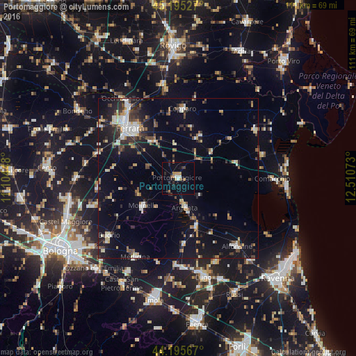
Analysis of Portomaggiore night lights 2016
Square area 10x10 km:
 0.76%
0.76%90-99
1.67%80-89
0.61%70-79
2.27%60-69
2.73%50-59
0.76%40-49
0.61%30-39
2.27%20-29
4.09%10-19
3.33%0-9
80.91%Square area 50x50 km:
1.53%90-99
2.14%80-89
1.07%70-79
1.35%60-69
1.24%50-59
1.55%40-49
1.93%30-39
1.97%20-29
3.53%10-19
9.75%0-9
73.95%Clear (daylight) street map image can be seen on geolist.org.
Map coordinates:
45° 11' 43" North, 11° 6' 16.1" East
44° 41' 51.5" North, 11° 48' 27.4" East
44° 11' 44.4" North, 12° 30' 38.6" East
Some cities around Portomaggiore sort by population:
• Ferrara
21.5 km =13.4 mi,  316°
316°
• Alfonsine
27.9 km =17.3 mi,  139°
139°
• Molinella
14.2 km =8.8 mi,  231°
231°
• Copparo
21.7 km =13.5 mi,  3°
3°
• Medicina-Buda
27.8 km =17.3 mi,  208°
208°
• Santa Maria Maddalena
27.7 km =17.2 mi,  325°
325°
• Argenta
9.6 km =6 mi,  166°
166°
• Poggio Renatico
26.4 km =16.4 mi,  286°
286°
3170082 (p: 7,440)
Sources (retrieved 2019-11-25):
» Earth at Night: Flat Maps 2012, 2016