Alfonsine night lights from space
Night Light of Alfonsine (Emilia-Romagna) from space (Italy) Src. Average luminocity for 10x10km area is 18.7651% and for 50x50km: 18.3115%.
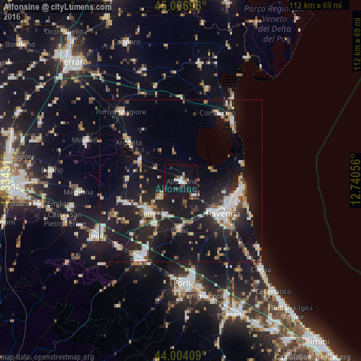
Analysis of Alfonsine night lights 2016
Square area 10x10 km:
 3.17%
3.17%90-99
3.02%80-89
1.27%70-79
0.48%60-69
0.63%50-59
1.59%40-49
3.02%30-39
4.13%20-29
2.38%10-19
30.48%0-9
49.84%Square area 50x50 km:
2.74%90-99
3.33%80-89
1.29%70-79
1.66%60-69
1.79%50-59
2.18%40-49
2.21%30-39
1.97%20-29
6.09%10-19
21.8%0-9
54.94%Clear (daylight) street map image can be seen on geolist.org.
Map coordinates:
45° 0' 25.1" North, 11° 20' 3.5" East
44° 30' 27.6" North, 12° 2' 14.7" East
44° 0' 14.7" North, 12° 44' 26" East
Some cities around Alfonsine sort by population:
• Ravenna
16.7 km =10.4 mi,  128°
128°
• Lugo
13.9 km =8.6 mi,  226°
226°
• Massa Lombarda
18.5 km =11.5 mi,  248°
248°
• Bagnacavallo
11.4 km =7.1 mi,  204°
204°
• Argenta
19.9 km =12.4 mi,  306°
306°
• Russi
14.6 km =9.1 mi,  181°
181°
• Fusignano
7.9 km =4.9 mi, 234°
• Lido Adriano
23.6 km =14.7 mi,  115°
115°
3183287 (p: 9,838)
Sources (retrieved 2019-11-25):
» Earth at Night: Flat Maps 2012, 2016