Ponzano night lights from space
Night Light of Ponzano (Veneto) from space (Italy) Src. Average luminocity for 10x10km area is 64.303% and for 50x50km: 43.7882%.
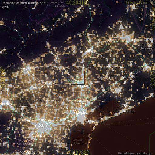
Analysis of Ponzano night lights 2016
Square area 10x10 km:
 10.61%
90-99
16.82%80-89
7.12%70-79
7.42%60-69
14.39%50-59
10.76%40-49
9.39%30-39
11.36%20-29
10%10-19
2.12%0-9
0%Square area 50x50 km:
4.61%90-99
7.06%80-89
4.24%70-79
5.2%60-69
7.8%50-59
9.62%40-49
9.99%30-39
9.1%20-29
17.44%10-19
17.64%0-9
7.28%Clear (daylight) street map image can be seen on geolist.org.
Map coordinates:
46° 12' 15.1" North, 11° 30' 4.8" East
45° 42' 55.5" North, 12° 12' 16" East
45° 13' 20.4" North, 12° 54' 27.3" East
Some cities around Ponzano sort by population:
• Treviso
6.1 km =3.8 mi,  151°
151°
• Lancenigo-Villorba
4.1 km =2.5 mi,  93°
93°
• Spresiano
8.1 km =5 mi,  29°
29°
• Paese
5.6 km =3.5 mi,  214°
214°
• Quinto di Treviso
8.6 km =5.3 mi,  200°
200°
• Silea
9.9 km =6.2 mi,  133°
133°
• Frescada
10 km =6.2 mi,  165°
165°
• Dosson
9.6 km =6 mi,  156°
156°
3218772 (p: 10,238)
Sources (retrieved 2019-11-25):
» Earth at Night: Flat Maps 2012, 2016