Silea night lights from space
Night Light of Silea (Veneto) from space (Italy) Src. Average luminocity for 10x10km area is 64.9485% and for 50x50km: 44.9126%.
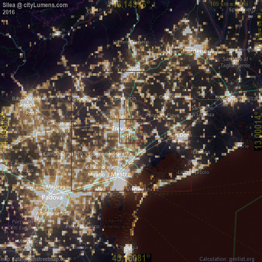
Analysis of Silea night lights 2016
Square area 10x10 km:
 11.36%
90-99
14.7%80-89
5.76%70-79
6.36%60-69
13.18%50-59
18.64%40-49
11.52%30-39
12.27%20-29
6.21%10-19
0%0-9
0%Square area 50x50 km:
6.16%90-99
8.23%80-89
4.33%70-79
5%60-69
7.64%50-59
9.22%40-49
8.12%30-39
7.8%20-29
17.18%10-19
18.56%0-9
7.76%Clear (daylight) street map image can be seen on geolist.org.
Map coordinates:
46° 8' 37.5" North, 11° 35' 38" East
45° 39' 16" North, 12° 17' 49.2" East
45° 9' 38.9" North, 13° 0' 0.5" East
Some cities around Silea sort by population:
• Treviso
4.5 km =2.8 mi,  287°
287°
• Lancenigo-Villorba
7.2 km =4.5 mi,  334°
334°
• Ponzano
9.9 km =6.2 mi,  313°
313°
• Casale sul Sile
6.9 km =4.3 mi,  160°
160°
• Preganziol
7.5 km =4.7 mi,  218°
218°
• Roncade
7.2 km =4.5 mi,  120°
120°
• Frescada
5.5 km =3.4 mi,  238°
238°
• Dosson
3.9 km =2.4 mi, 238°
3166532 (p: 6,077)
Sources (retrieved 2019-11-25):
» Earth at Night: Flat Maps 2012, 2016