Quinto di Treviso night lights from space
Night Light of Quinto di Treviso (Veneto) from space (Italy) Src. Average luminocity for 10x10km area is 57.1985% and for 50x50km: 49.1292%.
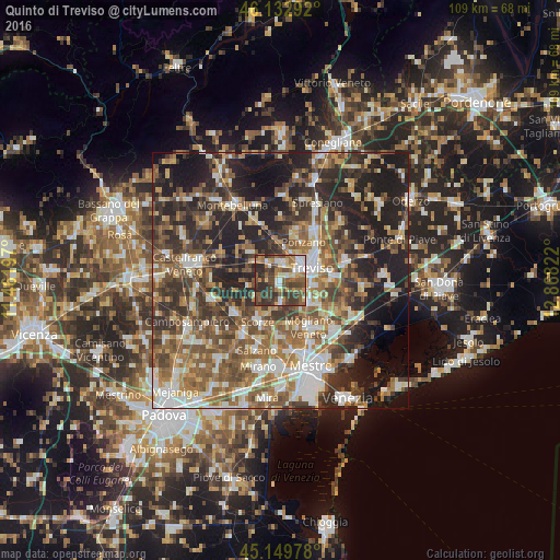
Analysis of Quinto di Treviso night lights 2016
Square area 10x10 km:
 7.58%
7.58%90-99
9.39%80-89
5.15%70-79
6.67%60-69
9.7%50-59
13.94%40-49
18.48%30-39
17.88%20-29
11.21%10-19
0%0-9
0%Square area 50x50 km:
6.84%90-99
8.95%80-89
4.71%70-79
5.71%60-69
8.98%50-59
10.98%40-49
10%30-39
9.2%20-29
14.92%10-19
15.33%0-9
4.38%Clear (daylight) street map image can be seen on geolist.org.
Map coordinates:
46° 7' 58.5" North, 11° 27' 43.1" East
45° 38' 36.6" North, 12° 9' 54.3" East
45° 8' 59.2" North, 12° 52' 5.6" East
Some cities around Quinto di Treviso sort by population:
• Treviso
6.5 km =4 mi,  66°
66°
• Ponzano
8.6 km =5.3 mi,  20°
20°
• Paese
3.4 km =2.1 mi,  358°
358°
• Scorzè
8.8 km =5.5 mi,  208°
208°
• Preganziol
7.3 km =4.5 mi,  129°
129°
• Zero Branco
4.9 km =3 mi,  181°
181°
• Frescada
5.8 km =3.6 mi,  106°
106°
• Dosson
7 km =4.3 mi,  96°
96°
3169663 (p: 6,796)
Sources (retrieved 2019-11-25):
» Earth at Night: Flat Maps 2012, 2016