Paese night lights from space
Night Light of Paese (Veneto) from space (Italy) Src. Average luminocity for 10x10km area is 57.8591% and for 50x50km: 47.2439%.
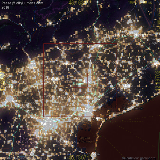
Analysis of Paese night lights 2016
Square area 10x10 km:
 6.82%
6.82%90-99
11.06%80-89
6.06%70-79
7.27%60-69
13.33%50-59
12.42%40-49
13.33%30-39
12.12%20-29
17.58%10-19
0%0-9
0%Square area 50x50 km:
5.96%90-99
8.09%80-89
4.45%70-79
5.51%60-69
8.75%50-59
10.72%40-49
10.29%30-39
9.08%20-29
15.6%10-19
16.72%0-9
4.83%Clear (daylight) street map image can be seen on geolist.org.
Map coordinates:
46° 9' 47.9" North, 11° 27' 38.8" East
45° 40' 27" North, 12° 9' 50" East
45° 10' 50.6" North, 12° 52' 1.3" East
Some cities around Paese sort by population:
• Treviso
6.1 km =3.8 mi,  97°
97°
• Lancenigo-Villorba
8.4 km =5.2 mi,  59°
59°
• Ponzano
5.6 km =3.5 mi,  34°
34°
• Quinto di Treviso
3.4 km =2.1 mi,  178°
178°
• Preganziol
9.9 km =6.2 mi,  144°
144°
• Zero Branco
8.3 km =5.2 mi, 180°
• Frescada
7.6 km =4.7 mi,  131°
131°
• Dosson
8.2 km =5.1 mi,  121°
121°
3171710 (p: 9,395)
Sources (retrieved 2019-11-25):
» Earth at Night: Flat Maps 2012, 2016