Spresiano night lights from space
Night Light of Spresiano (Veneto) from space (Italy) Src. Average luminocity for 10x10km area is 47.9603% and for 50x50km: 40.1188%.
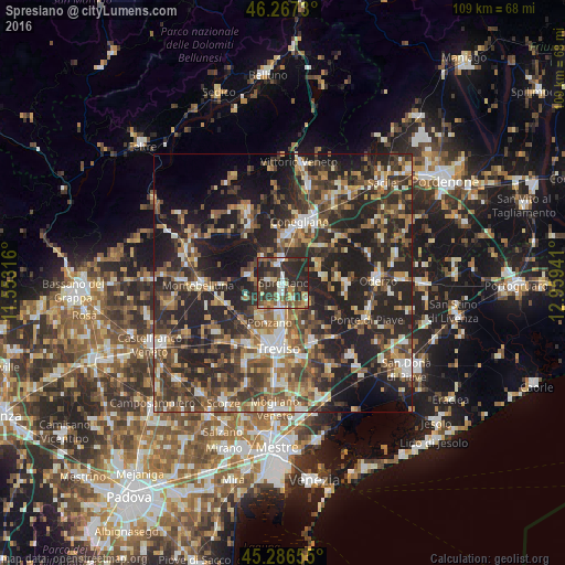
Analysis of Spresiano night lights 2016
Square area 10x10 km:
 4.6%
4.6%90-99
8.41%80-89
4.76%70-79
5.4%60-69
6.51%50-59
9.21%40-49
10.32%30-39
16.19%20-29
31.9%10-19
2.7%0-9
0%Square area 50x50 km:
3.54%90-99
6.25%80-89
3.91%70-79
4.91%60-69
6.61%50-59
7.7%40-49
9.13%30-39
9%20-29
20.03%10-19
19.67%0-9
9.25%Clear (daylight) street map image can be seen on geolist.org.
Map coordinates:
46° 16' 2.3" North, 11° 33' 11.4" East
45° 46' 44.7" North, 12° 15' 22.6" East
45° 17' 11.6" North, 12° 57' 33.9" East
Some cities around Spresiano sort by population:
• Treviso
12.5 km =7.8 mi,  185°
185°
• Conegliano
12.6 km =7.8 mi,  16°
16°
• Lancenigo-Villorba
7.4 km =4.6 mi,  179°
179°
• Ponzano
8.1 km =5 mi,  209°
209°
• Santa Lucia di Piave
9.6 km =6 mi, 17°
• Mareno di Piave
9.7 km =6 mi,  40°
40°
• Priula-Colfosco
4.6 km =2.9 mi,  2°
2°
• Vazzola
13.3 km =8.3 mi,  62°
62°
3166227 (p: 10,287)
Sources (retrieved 2019-11-25):
» Earth at Night: Flat Maps 2012, 2016