Pontecorvo night lights from space
Night Light of Pontecorvo (Latium) from space (Italy) Src. Average luminocity for 10x10km area is 19.381% and for 50x50km: 18.7688%.
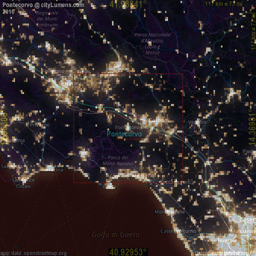
Analysis of Pontecorvo night lights 2016
Square area 10x10 km:
 0.85%
0.85%90-99
1.87%80-89
1.87%70-79
1.87%60-69
2.21%50-59
3.74%40-49
1.19%30-39
4.59%20-29
5.27%10-19
31.97%0-9
44.56%Square area 50x50 km:
0.66%90-99
2.41%80-89
1.43%70-79
2.19%60-69
2.61%50-59
4.04%40-49
3.92%30-39
3.96%20-29
6.74%10-19
19.02%0-9
53.01%Clear (daylight) street map image can be seen on geolist.org.
Map coordinates:
41° 59' 0.3" North, 12° 57' 47" East
41° 27' 31" North, 13° 39' 58.2" East
40° 55' 46.3" North, 14° 22' 9.5" East
Some cities around Pontecorvo sort by population:
• Formia
23 km =14.3 mi,  192°
192°
• Fondi
22.9 km =14.2 mi,  240°
240°
• Cassino
13.8 km =8.6 mi,  77°
77°
• Gaeta
28.3 km =17.6 mi,  196°
196°
• Minturno
22.7 km =14.1 mi,  163°
163°
• Isola del Liri
26 km =16.2 mi,  347°
347°
• Itri
21.9 km =13.6 mi,  211°
211°
• Ceprano
15.9 km =9.9 mi,  307°
307°
3170286 (p: 7,994)
Sources (retrieved 2019-11-25):
» Earth at Night: Flat Maps 2012, 2016