Minturno night lights from space
Night Light of Minturno (Latium) from space (Italy) Src. Average luminocity for 10x10km area is 38.1023% and for 50x50km: 14.7254%.
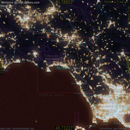
Analysis of Minturno night lights 2016
Square area 10x10 km:
 1.46%
1.46%90-99
7.14%80-89
4.06%70-79
4.38%60-69
4.55%50-59
7.47%40-49
10.06%30-39
6.66%20-29
16.23%10-19
36.36%0-9
1.62%Square area 50x50 km:
0.67%90-99
2.34%80-89
1.31%70-79
1.41%60-69
1.74%50-59
2.73%40-49
2.38%30-39
2.21%20-29
3.74%10-19
18.91%0-9
62.56%Clear (daylight) street map image can be seen on geolist.org.
Map coordinates:
41° 47' 21.6" North, 13° 2' 33.8" East
41° 15' 46.6" North, 13° 44' 45" East
40° 43' 56.2" North, 14° 26' 56.3" East
Some cities around Minturno sort by population:
• Formia
11.5 km =7.1 mi,  266°
266°
• Mondragone
20.6 km =12.8 mi,  143°
143°
• Cassino
25.7 km =16 mi,  15°
15°
• Gaeta
15.6 km =9.7 mi,  249°
249°
• Itri
18.3 km =11.4 mi,  279°
279°
• Pontecorvo
22.7 km =14.1 mi,  343°
343°
• Cellole
11.2 km =7 mi,  126°
126°
• Sessa Aurunca
15.6 km =9.7 mi,  99°
99°
3173391 (p: 16,236)
Sources (retrieved 2019-11-25):
» Earth at Night: Flat Maps 2012, 2016