Pianiga night lights from space
Night Light of Pianiga (Veneto) from space (Italy) Src. Average luminocity for 10x10km area is 70.5524% and for 50x50km: 52.9694%.
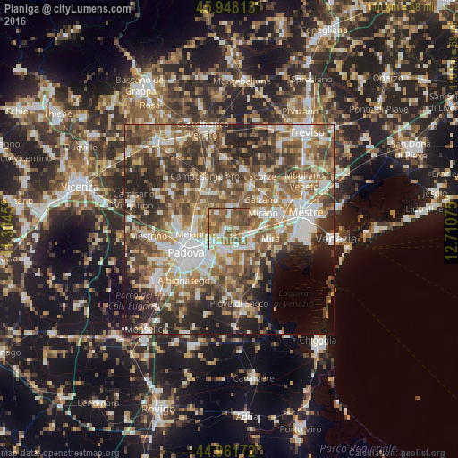
Analysis of Pianiga night lights 2016
Square area 10x10 km:
 11.75%
90-99
16.83%80-89
6.51%70-79
6.83%60-69
16.67%50-59
30.32%40-49
10.16%30-39
0.95%20-29
0%10-19
0%0-9
0%Square area 50x50 km:
9.23%90-99
10.72%80-89
4.96%70-79
6.46%60-69
9.2%50-59
11.71%40-49
11.02%30-39
9.33%20-29
10.95%10-19
6.99%0-9
9.43%Clear (daylight) street map image can be seen on geolist.org.
Map coordinates:
45° 56' 53.3" North, 11° 18' 16.2" East
45° 27' 25.5" North, 12° 0' 27.4" East
44° 57' 42.2" North, 12° 42' 38.7" East
Some cities around Pianiga sort by population:
• Vigonza
3.6 km =2.2 mi,  226°
226°
• Campodarsego
8.1 km =5 mi,  304°
304°
• Mejaniga
7.9 km =4.9 mi,  270°
270°
• Noventa
6.5 km =4 mi,  222°
222°
• Dolo
6.9 km =4.3 mi,  120°
120°
• Fiesso
4.6 km =2.9 mi,  153°
153°
• Stra
5.1 km =3.2 mi,  174°
174°
• Fiesso d'Artico
4.3 km =2.7 mi,  156°
156°
3170963 (p: 6,169)
Sources (retrieved 2019-11-25):
» Earth at Night: Flat Maps 2012, 2016