Campodarsego night lights from space
Night Light of Campodarsego (Veneto) from space (Italy) Src. Average luminocity for 10x10km area is 66.7238% and for 50x50km: 53.4748%.
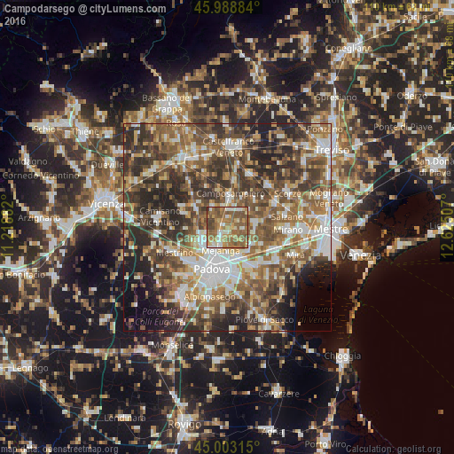
Analysis of Campodarsego night lights 2016
Square area 10x10 km:
 5.4%
5.4%90-99
10.63%80-89
7.94%70-79
12.86%60-69
18.89%50-59
31.59%40-49
10.48%30-39
2.22%20-29
0%10-19
0%0-9
0%Square area 50x50 km:
8.08%90-99
10.23%80-89
5.19%70-79
6.79%60-69
9.42%50-59
12.49%40-49
11.92%30-39
10.38%20-29
12.92%10-19
6.53%0-9
6.04%Clear (daylight) street map image can be seen on geolist.org.
Map coordinates:
45° 59' 19.8" North, 11° 13' 7.8" East
45° 29' 53.3" North, 11° 55' 19" East
45° 0' 11.3" North, 12° 37' 30.3" East
Some cities around Campodarsego sort by population:
• Vigonza
8.2 km =5.1 mi,  149°
149°
• Mejaniga
4.7 km =2.9 mi,  195°
195°
• Noventa
9.6 km =6 mi,  166°
166°
• San Giorgio delle Pertiche
5.2 km =3.2 mi,  335°
335°
• Vigodarzere
5.3 km =3.3 mi,  212°
212°
• Pianiga
8.1 km =5 mi,  124°
124°
• Borgoricco-San Michele delle Badesse-Sant'Eufemia
4.4 km =2.7 mi,  19°
19°
• Limena
6.7 km =4.2 mi,  241°
241°
3180983 (p: 11,971)
Sources (retrieved 2019-11-25):
» Earth at Night: Flat Maps 2012, 2016