Stra night lights from space
Night Light of Stra (Veneto) from space (Italy) Src. Average luminocity for 10x10km area is 76.446% and for 50x50km: 50.0621%.
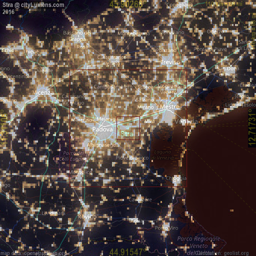
Analysis of Stra night lights 2016
Square area 10x10 km:
100  16.67%
90-99 19.68%
80-89 8.89%
70-79 11.59%
60-69 18.25%
50-59 17.94%
40-49 6.19%
30-39 0.79%
20-29 0%
10-19 0%
0-9 0%
16.67%90-99
19.68%80-89
8.89%70-79
11.59%60-69
18.25%50-59
17.94%40-49
6.19%30-39
0.79%20-29
0%10-19
0%0-9
0%Square area 50x50 km:
100 8.76%
90-99 9.98%
80-89 4.6%
70-79 6.12%
60-69 8.49%
50-59 10.31%
40-49 10.23%
30-39 9.1%
20-29 11.31%
10-19 8.88%
0-9 12.22%
8.76%90-99
9.98%80-89
4.6%70-79
6.12%60-69
8.49%50-59
10.31%40-49
10.23%30-39
9.1%20-29
11.31%10-19
8.88%0-9
12.22%Clear (daylight) street map image can be seen on geolist.org.
Map coordinates:
45° 54' 9.6" North, 11° 18' 39.8" East
45° 24' 40.4" North, 12° 0' 51" East
44° 54' 55.7" North, 12° 43' 2.3" East
Some cities around Stra sort by population:
• Vigonza
4.1 km =2.5 mi,  310°
310°
• Noventa
4.9 km =3 mi,  273°
273°
• Dolo
5.7 km =3.5 mi,  74°
74°
• Fiesso
1.8 km =1.1 mi,  58°
58°
• Pianiga
5.1 km =3.2 mi,  354°
354°
• Villatora
4.5 km =2.8 mi,  234°
234°
• Fiesso d'Artico
1.6 km =1 mi,  46°
46°
• Fossò
3.8 km =2.4 mi,  138°
138°
3166122 (p: 6,200)
Sources (retrieved 2019-11-25):
» Earth at Night: Flat Maps 2012, 2016