Dolo night lights from space
Night Light of Dolo (Veneto) from space (Italy) Src. Average luminocity for 10x10km area is 68.9111% and for 50x50km: 48.3266%.
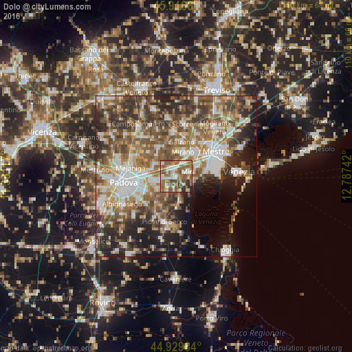
Analysis of Dolo night lights 2016
Square area 10x10 km:
100  11.9%
11.9%
90-99 14.6%
80-89 8.41%
70-79 7.3%
60-69 16.83%
50-59 23.97%
40-49 9.37%
30-39 3.33%
20-29 3.81%
10-19 0.48%
0-9 0%
11.9%90-99
14.6%80-89
8.41%70-79
7.3%60-69
16.83%50-59
23.97%40-49
9.37%30-39
3.33%20-29
3.81%10-19
0.48%0-9
0%Square area 50x50 km:
100 8.66%
90-99 9.76%
80-89 4.52%
70-79 5.68%
60-69 8.37%
50-59 10.09%
40-49 9.7%
30-39 8.3%
20-29 9.72%
10-19 9.14%
0-9 16.06%
8.66%90-99
9.76%80-89
4.52%70-79
5.68%60-69
8.37%50-59
10.09%40-49
9.7%30-39
8.3%20-29
9.72%10-19
9.14%0-9
16.06%Clear (daylight) street map image can be seen on geolist.org.
Map coordinates:
45° 54' 59.8" North, 11° 22' 52.2" East
45° 25' 31" North, 12° 5' 3.4" East
44° 55' 46.7" North, 12° 47' 14.7" East
Some cities around Dolo sort by population:
• Mira Taglio
3.7 km =2.3 mi,  73°
73°
• Mirano
7.9 km =4.9 mi,  13°
13°
• Camponogara
5.1 km =3.2 mi,  178°
178°
• Fiesso
4 km =2.5 mi,  260°
260°
• Stra
5.7 km =3.5 mi,  254°
254°
• Pianiga
6.9 km =4.3 mi,  300°
300°
• Fiesso d'Artico
4.3 km =2.7 mi, 264°
• Fossò
5.3 km =3.3 mi,  214°
214°
3177547 (p: 8,410)
Sources (retrieved 2019-11-25):
» Earth at Night: Flat Maps 2012, 2016