Mejaniga night lights from space
Night Light of Mejaniga (Veneto) from space (Italy) Src. Average luminocity for 10x10km area is 81.8873% and for 50x50km: 51.2033%.
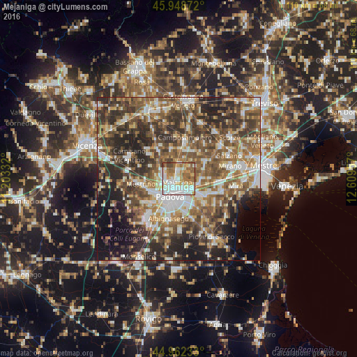
Analysis of Mejaniga night lights 2016
Square area 10x10 km:
 24.6%
24.6%90-99
23.17%80-89
10.63%70-79
10.32%60-69
14.6%50-59
13.02%40-49
3.33%30-39
0.32%20-29
0%10-19
0%0-9
0%Square area 50x50 km:
7.48%90-99
9.82%80-89
4.91%70-79
6.44%60-69
8.74%50-59
11.49%40-49
11.4%30-39
10.06%20-29
13.46%10-19
9.47%0-9
6.73%Clear (daylight) street map image can be seen on geolist.org.
Map coordinates:
45° 56' 55.4" North, 11° 12' 12" East
45° 27' 27.6" North, 11° 54' 23.2" East
44° 57' 44.4" North, 12° 36' 34.5" East
Some cities around Mejaniga sort by population:
• Padova
5.8 km =3.6 mi,  196°
196°
• Vigonza
5.9 km =3.7 mi,  115°
115°
• Campodarsego
4.7 km =2.9 mi,  15°
15°
• Noventa
5.9 km =3.7 mi,  144°
144°
• Sarmeola
7.9 km =4.9 mi,  241°
241°
• Vigodarzere
1.6 km =1 mi,  269°
269°
• Pianiga
7.9 km =4.9 mi,  90°
90°
• Limena
4.9 km =3 mi,  285°
285°
8948732 (p: 11,434)
Sources (retrieved 2019-11-25):
» Earth at Night: Flat Maps 2012, 2016