Fiesso night lights from space
Night Light of Fiesso (Veneto) from space (Italy) Src. Average luminocity for 10x10km area is 75.6857% and for 50x50km: 50.3045%.
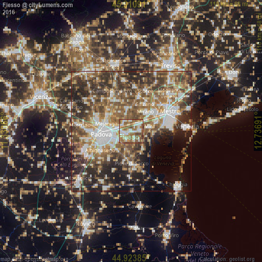
Analysis of Fiesso night lights 2016
Square area 10x10 km:
100  14.13%
90-99 21.43%
80-89 7.62%
70-79 11.27%
60-69 18.1%
50-59 20.79%
40-49 6.03%
30-39 0.63%
20-29 0%
10-19 0%
0-9 0%
14.13%90-99
21.43%80-89
7.62%70-79
11.27%60-69
18.1%50-59
20.79%40-49
6.03%30-39
0.63%20-29
0%10-19
0%0-9
0%Square area 50x50 km:
100 8.8%
90-99 10.04%
80-89 4.69%
70-79 6.15%
60-69 8.54%
50-59 10.5%
40-49 10.47%
30-39 9.06%
20-29 11.08%
10-19 8.05%
0-9 12.62%
8.8%90-99
10.04%80-89
4.69%70-79
6.15%60-69
8.54%50-59
10.5%40-49
10.47%30-39
9.06%20-29
11.08%10-19
8.05%0-9
12.62%Clear (daylight) street map image can be seen on geolist.org.
Map coordinates:
45° 54' 39.3" North, 11° 19' 50.4" East
45° 25' 10.3" North, 12° 2' 1.6" East
44° 55' 25.9" North, 12° 44' 12.9" East
Some cities around Fiesso sort by population:
• Vigonza
4.9 km =3 mi,  290°
290°
• Camponogara
6.1 km =3.8 mi,  137°
137°
• Noventa
6.5 km =4 mi,  264°
264°
• Dolo
4 km =2.5 mi,  80°
80°
• Stra
1.8 km =1.1 mi,  238°
238°
• Pianiga
4.6 km =2.9 mi,  333°
333°
• Villatora
6.3 km =3.9 mi, 235°
• Fossò
3.9 km =2.4 mi,  165°
165°
8948755 (p: 7,372)
Sources (retrieved 2019-11-25):
» Earth at Night: Flat Maps 2012, 2016