Sant'Antonio night lights from space
Night Light of Sant'Antonio (Lombardy) from space (Italy) Src. Average luminocity for 10x10km area is 52.5758% and for 50x50km: 31.8043%.
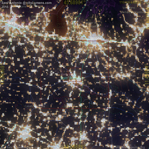
Analysis of Sant'Antonio night lights 2016
Square area 10x10 km:
 10.45%
90-99
16.21%80-89
4.55%70-79
4.09%60-69
1.82%50-59
6.06%40-49
6.52%30-39
11.06%20-29
27.88%10-19
11.36%0-9
0%Square area 50x50 km:
3.99%90-99
5.94%80-89
2.87%70-79
2.92%60-69
3.56%50-59
4.43%40-49
4.41%30-39
5%20-29
13.04%10-19
33.96%0-9
19.88%Clear (daylight) street map image can be seen on geolist.org.
Map coordinates:
45° 41' 23.3" North, 10° 5' 26.5" East
45° 11' 47.4" North, 10° 47' 37.7" East
44° 41' 55.9" North, 11° 29' 49" East
Some cities around Sant'Antonio sort by population:
• Mantova
4 km =2.5 mi,  175°
175°
• Villafranca di Verona
18 km =11.2 mi,  12°
12°
• Mottella
5.4 km =3.4 mi,  132°
132°
• Cerese
8.7 km =5.4 mi, 182°
• Vigasio
17.9 km =11.1 mi,  41°
41°
• Goito
12 km =7.5 mi,  300°
300°
• Marmirolo
3.9 km =2.4 mi,  310°
310°
• Eremo
8.3 km =5.2 mi,  208°
208°
3167409 (p: 13,596)
Sources (retrieved 2019-11-25):
» Earth at Night: Flat Maps 2012, 2016