Goito night lights from space
Night Light of Goito (Lombardy) from space (Italy) Src. Average luminocity for 10x10km area is 22.6182% and for 50x50km: 34.975%.
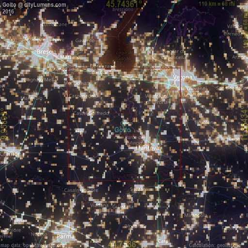
Analysis of Goito night lights 2016
Square area 10x10 km:
 1.82%
1.82%90-99
3.33%80-89
1.06%70-79
1.52%60-69
1.67%50-59
1.82%40-49
3.33%30-39
3.79%20-29
5.76%10-19
70.61%0-9
5.3%Square area 50x50 km:
5.13%90-99
6.93%80-89
3.18%70-79
3.03%60-69
4.44%50-59
4.47%40-49
4.69%30-39
6.11%20-29
13.64%10-19
32.46%0-9
15.92%Clear (daylight) street map image can be seen on geolist.org.
Map coordinates:
45° 44' 37" North, 9° 57' 29.1" East
45° 15' 2.7" North, 10° 39' 40.4" East
44° 45' 13" North, 11° 21' 51.6" East
Some cities around Goito sort by population:
• Mantova
14.7 km =9.1 mi,  133°
133°
• Sant'Antonio
12 km =7.5 mi,  120°
120°
• Castel Goffredo
15.5 km =9.6 mi,  288°
288°
• Valeggio sul Mincio
12.8 km =8 mi,  27°
27°
• Mottella
17.3 km =10.7 mi, 123°
• Cerese
17.8 km =11.1 mi,  145°
145°
• Marmirolo
8.2 km =5.1 mi, 115°
• Eremo
14.7 km =9.1 mi, 154°
3176014 (p: 5,538)
Sources (retrieved 2019-11-25):
» Earth at Night: Flat Maps 2012, 2016