Piazza del Galdo-Sant'Angelo night lights from space
Night Light of Piazza del Galdo-Sant'Angelo (Campania) from space (Italy) Src. Average luminocity for 10x10km area is 70.6023% and for 50x50km: 41.4448%.
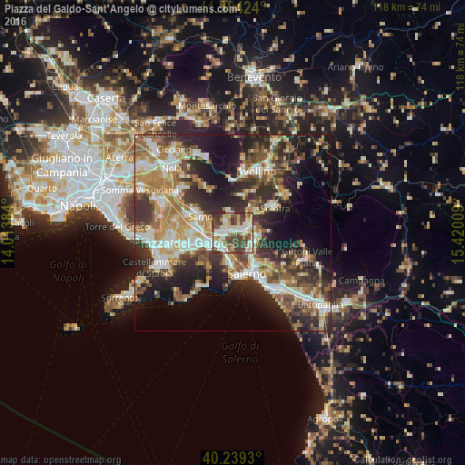
Analysis of Piazza del Galdo-Sant'Angelo night lights 2016
Square area 10x10 km:
 13.8%
13.8%90-99
22.73%80-89
9.25%70-79
6.33%60-69
8.12%50-59
10.06%40-49
17.37%30-39
11.2%20-29
1.14%10-19
0%0-9
0%Square area 50x50 km:
5.94%90-99
8.52%80-89
4.86%70-79
5.76%60-69
6.99%50-59
6.78%40-49
5.73%30-39
8.09%20-29
11.68%10-19
13.73%0-9
21.91%Clear (daylight) street map image can be seen on geolist.org.
Map coordinates:
41° 18' 15.3" North, 14° 0' 49.8" East
40° 46' 26" North, 14° 43' 1.1" East
40° 14' 21.5" North, 15° 25' 12.3" East
Some cities around Piazza del Galdo-Sant'Angelo sort by population:
• Nocera Superiore
5 km =3.1 mi,  225°
225°
• Baronissi
5.6 km =3.5 mi,  120°
120°
• Mercato San Severino
3.3 km =2.1 mi,  68°
68°
• Siano
3.7 km =2.3 mi,  327°
327°
• Castel San Giorgio
1.6 km =1 mi,  303°
303°
• Roccapiemonte
2.7 km =1.7 mi,  235°
235°
• Lanzara
3.4 km =2.1 mi,  271°
271°
• Bracigliano
5.1 km =3.2 mi,  351°
351°
8948776 (p: 5,742)
Sources (retrieved 2019-11-25):
» Earth at Night: Flat Maps 2012, 2016