Bracigliano night lights from space
Night Light of Bracigliano (Campania) from space (Italy) Src. Average luminocity for 10x10km area is 50.1956% and for 50x50km: 45.2667%.
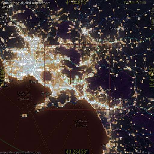
Analysis of Bracigliano night lights 2016
Square area 10x10 km:
 6.46%
6.46%90-99
13.78%80-89
7.14%70-79
2.89%60-69
5.61%50-59
5.1%40-49
7.31%30-39
13.95%20-29
23.98%10-19
13.78%0-9
0%Square area 50x50 km:
6.14%90-99
9.24%80-89
5.46%70-79
6.07%60-69
7.81%50-59
7.49%40-49
6.25%30-39
8.83%20-29
14.33%10-19
15.24%0-9
13.14%Clear (daylight) street map image can be seen on geolist.org.
Map coordinates:
41° 20' 55.6" North, 14° 0' 16.6" East
40° 49' 7.7" North, 14° 42' 27.8" East
40° 17' 4.4" North, 15° 24' 39.1" East
Some cities around Bracigliano sort by population:
• Sarno
7.4 km =4.6 mi,  260°
260°
• Mercato San Severino
5.4 km =3.4 mi,  134°
134°
• Siano
2.2 km =1.4 mi,  213°
213°
• Montoro Superiore
7.6 km =4.7 mi,  91°
91°
• Castel San Giorgio
4.1 km =2.5 mi,  187°
187°
• Roccapiemonte
6.7 km =4.2 mi, 192°
• Piazza del Galdo-Sant'Angelo
5.1 km =3.2 mi,  171°
171°
• Lanzara
5.6 km =3.5 mi, 208°
3181622 (p: 5,375)
Sources (retrieved 2019-11-25):
» Earth at Night: Flat Maps 2012, 2016