Matelica night lights from space
Night Light of Matelica (The Marches) from space (Italy) Src. Average luminocity for 10x10km area is 13.0227% and for 50x50km: 7.2679%.
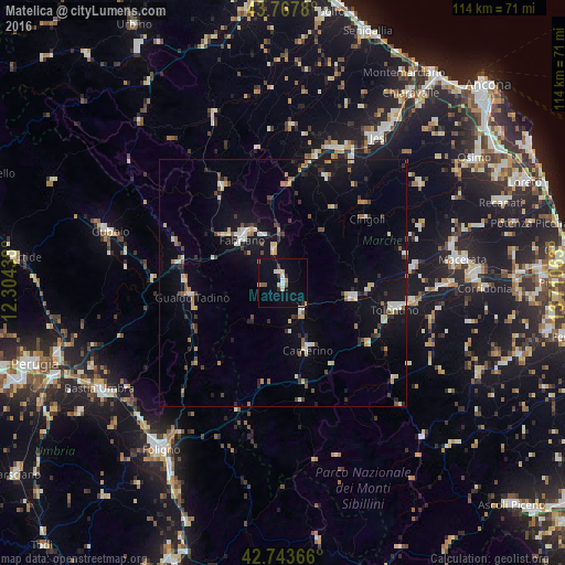
Analysis of Matelica night lights 2016
Square area 10x10 km:
 1.21%
1.21%90-99
2.42%80-89
2.12%70-79
0.91%60-69
1.21%50-59
1.21%40-49
1.21%30-39
0.61%20-29
1.82%10-19
4.24%0-9
83.03%Square area 50x50 km:
0.5%90-99
1.31%80-89
0.79%70-79
0.77%60-69
0.79%50-59
0.46%40-49
0.96%30-39
0.98%20-29
1.46%10-19
5.27%0-9
86.7%Clear (daylight) street map image can be seen on geolist.org.
Map coordinates:
43° 46' 4.1" North, 12° 18' 15.8" East
43° 15' 28.4" North, 13° 0' 27" East
42° 44' 37.2" North, 13° 42' 38.3" East
Some cities around Matelica sort by population:
• Jesi
35 km =21.7 mi,  33°
33°
• Macerata
36.3 km =22.6 mi,  82°
82°
• Fabriano
12.4 km =7.7 mi,  317°
317°
• Tolentino
23.1 km =14.4 mi,  103°
103°
• Gubbio
36.6 km =22.7 mi,  286°
286°
• Gualdo Tadino
18.8 km =11.7 mi,  260°
260°
• San Severino Marche
14.3 km =8.9 mi, 102°
• Filottrano
34.1 km =21.2 mi,  54°
54°
3173722 (p: 8,891)
Sources (retrieved 2019-11-25):
» Earth at Night: Flat Maps 2012, 2016