Gubbio night lights from space
Night Light of Gubbio (Umbria) from space (Italy) Src. Average luminocity for 10x10km area is 16.4857% and for 50x50km: 5.2398%.
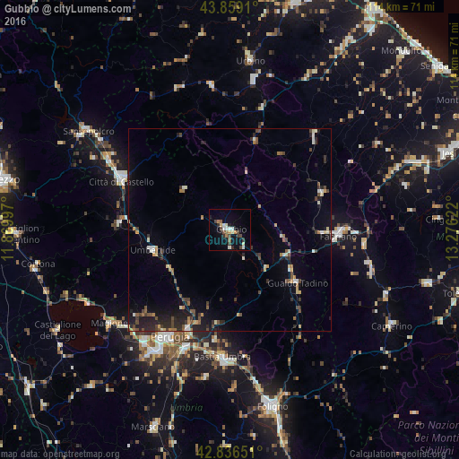
Analysis of Gubbio night lights 2016
Square area 10x10 km:
 0.95%
0.95%90-99
3.97%80-89
1.9%70-79
1.11%60-69
1.59%50-59
2.54%40-49
3.49%30-39
2.38%20-29
2.22%10-19
5.08%0-9
74.76%Square area 50x50 km:
0.24%90-99
0.75%80-89
0.45%70-79
0.57%60-69
0.56%50-59
0.63%40-49
1.31%30-39
0.83%20-29
1.6%10-19
2.89%0-9
90.17%Clear (daylight) street map image can be seen on geolist.org.
Map coordinates:
43° 51' 32.8" North, 11° 52' 11.9" East
43° 20' 59.9" North, 12° 34' 23.1" East
42° 50' 11.4" North, 13° 16' 34.4" East
Some cities around Gubbio sort by population:
• Perugia
30.4 km =18.9 mi,  209°
209°
• Fabriano
26.7 km =16.6 mi,  92°
92°
• Città di Castello
30 km =18.6 mi,  295°
295°
• Bastia umbra
31.8 km =19.8 mi,  183°
183°
• Umbertide
19.7 km =12.2 mi,  254°
254°
• Gualdo Tadino
21.4 km =13.3 mi,  128°
128°
• Cagli
22.9 km =14.2 mi,  16°
16°
• bishopric of Perugia
30.3 km =18.8 mi, 209°
3175687 (p: 14,378)
Sources (retrieved 2019-11-25):
» Earth at Night: Flat Maps 2012, 2016