San Severino Marche night lights from space
Night Light of San Severino Marche (The Marches) from space (Italy) Src. Average luminocity for 10x10km area is 11.1379% and for 50x50km: 10.5104%.
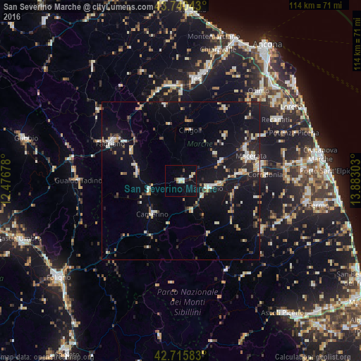
Analysis of San Severino Marche night lights 2016
Square area 10x10 km:
 0.45%
0.45%90-99
3.18%80-89
2.58%70-79
0.45%60-69
0.3%50-59
0.3%40-49
1.21%30-39
1.06%20-29
0.91%10-19
3.33%0-9
86.21%Square area 50x50 km:
0.88%90-99
2.14%80-89
1.13%70-79
0.89%60-69
1.04%50-59
0.91%40-49
1.08%30-39
1.33%20-29
2.57%10-19
9.98%0-9
78.06%Clear (daylight) street map image can be seen on geolist.org.
Map coordinates:
43° 44' 25.5" North, 12° 28' 36.4" East
43° 13' 49" North, 13° 10' 47.6" East
42° 42' 57" North, 13° 52' 58.9" East
Some cities around San Severino Marche sort by population:
• Jesi
32.8 km =20.4 mi,  9°
9°
• Macerata
23.4 km =14.5 mi,  71°
71°
• Fabriano
25.5 km =15.8 mi,  298°
298°
• Tolentino
8.9 km =5.5 mi,  105°
105°
• Gualdo Tadino
32.5 km =20.2 mi,  269°
269°
• Matelica
14.3 km =8.9 mi,  282°
282°
• Corridonia
26.6 km =16.5 mi,  86°
86°
• Filottrano
26.7 km =16.6 mi,  31°
31°
3167732 (p: 8,655)
Sources (retrieved 2019-11-25):
» Earth at Night: Flat Maps 2012, 2016