Maniago night lights from space
Night Light of Maniago (Friuli Venezia Giulia) from space (Italy) Src. Average luminocity for 10x10km area is 21.4673% and for 50x50km: 11.916%.
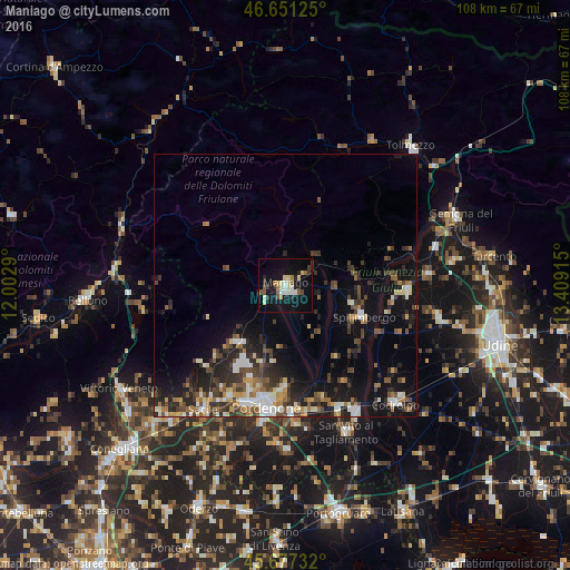
Analysis of Maniago night lights 2016
Square area 10x10 km:
 1.85%
1.85%90-99
3.41%80-89
4.69%70-79
1.42%60-69
1.99%50-59
2.7%40-49
2.13%30-39
3.41%20-29
2.84%10-19
23.01%0-9
52.56%Square area 50x50 km:
1.23%90-99
2.06%80-89
1.03%70-79
1.18%60-69
1.5%50-59
1.64%40-49
2.22%30-39
2.58%20-29
3.73%10-19
8.67%0-9
74.17%Clear (daylight) street map image can be seen on geolist.org.
Map coordinates:
46° 39' 4.5" North, 12° 0' 10.4" East
46° 9' 59.2" North, 12° 42' 21.7" East
45° 40' 38.4" North, 13° 24' 32.9" East
Some cities around Maniago sort by population:
• Pordenone
23.6 km =14.7 mi,  188°
188°
• Cordenons
20.3 km =12.6 mi,  181°
181°
• Spilimbergo
15.5 km =9.6 mi,  112°
112°
• Vigonovo-Fontanafredda
23.2 km =14.4 mi,  211°
211°
• Aviano
13.7 km =8.5 mi,  218°
218°
• San Daniele del Friuli
23.2 km =14.4 mi,  92°
92°
• Aviano-Castello
14.5 km =9 mi, 220°
• Roveredo in Piano
18.8 km =11.7 mi,  200°
200°
3174084 (p: 10,395)
Sources (retrieved 2019-11-25):
» Earth at Night: Flat Maps 2012, 2016