Cordenons night lights from space
Night Light of Cordenons (Friuli Venezia Giulia) from space (Italy) Src. Average luminocity for 10x10km area is 49.744% and for 50x50km: 23.5175%.
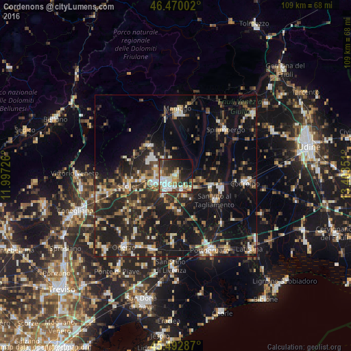
Analysis of Cordenons night lights 2016
Square area 10x10 km:
 9.97%
9.97%90-99
12.65%80-89
3.72%70-79
5.95%60-69
5.36%50-59
5.95%40-49
9.97%30-39
7.44%20-29
14.73%10-19
16.37%0-9
7.89%Square area 50x50 km:
1.96%90-99
3.65%80-89
2.09%70-79
2.44%60-69
3.18%50-59
3.43%40-49
4.26%30-39
4.74%20-29
10.48%10-19
22.62%0-9
41.14%Clear (daylight) street map image can be seen on geolist.org.
Map coordinates:
46° 28' 12.1" North, 11° 59' 50.1" East
45° 59' 1" North, 12° 42' 1.4" East
45° 29' 34.3" North, 13° 24' 12.6" East
Some cities around Cordenons sort by population:
• Pordenone
4.3 km =2.7 mi,  226°
226°
• Porcia
6.9 km =4.3 mi,  250°
250°
• Azzano Decimo
8.7 km =5.4 mi,  198°
198°
• Fiume Veneto
6.8 km =4.2 mi,  154°
154°
• Casarsa della Delizia
11.6 km =7.2 mi,  108°
108°
• Vigonovo-Fontanafredda
11.9 km =7.4 mi,  273°
273°
• Aviano
12.7 km =7.9 mi,  319°
319°
• Roveredo in Piano
6.8 km =4.2 mi,  293°
293°
3178112 (p: 15,962)
Sources (retrieved 2019-11-25):
» Earth at Night: Flat Maps 2012, 2016