Spilimbergo night lights from space
Night Light of Spilimbergo (Friuli Venezia Giulia) from space (Italy) Src. Average luminocity for 10x10km area is 17.8082% and for 50x50km: 17.4429%.
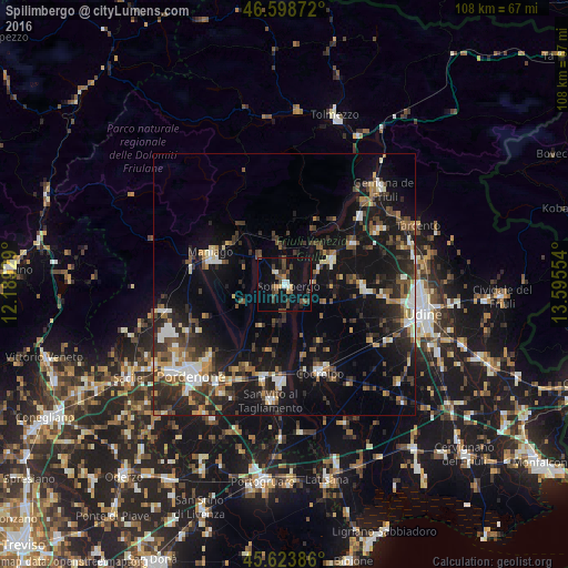
Analysis of Spilimbergo night lights 2016
Square area 10x10 km:
 0.99%
0.99%90-99
2.13%80-89
1.42%70-79
1.14%60-69
0.85%50-59
3.27%40-49
6.11%30-39
3.84%20-29
2.56%10-19
15.77%0-9
61.93%Square area 50x50 km:
1.67%90-99
2.74%80-89
1.47%70-79
1.58%60-69
1.95%50-59
2.75%40-49
3.15%30-39
3.73%20-29
5.98%10-19
16.72%0-9
58.26%Clear (daylight) street map image can be seen on geolist.org.
Map coordinates:
46° 35' 55.4" North, 12° 11' 21.4" East
46° 6' 48.4" North, 12° 53' 32.7" East
45° 37' 25.9" North, 13° 35' 43.9" East
Some cities around Spilimbergo sort by population:
• Rosa
20.4 km =12.7 mi,  184°
184°
• Codroipo
17.9 km =11.1 mi,  157°
157°
• Maniago
15.5 km =9.6 mi,  292°
292°
• Casarsa della Delizia
18.5 km =11.5 mi,  192°
192°
• San Daniele del Friuli
10.1 km =6.3 mi,  61°
61°
• Buia
20.5 km =12.7 mi, 57°
• Majano
15.4 km =9.6 mi, 57°
• Martignacco
19.2 km =11.9 mi,  96°
96°
3166262 (p: 9,422)
Sources (retrieved 2019-11-25):
» Earth at Night: Flat Maps 2012, 2016