Roveredo in Piano night lights from space
Night Light of Roveredo in Piano (Friuli Venezia Giulia) from space (Italy) Src. Average luminocity for 10x10km area is 55.2116% and for 50x50km: 22.748%.
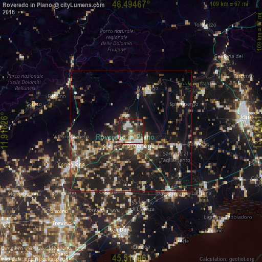
Analysis of Roveredo in Piano night lights 2016
Square area 10x10 km:
 10.94%
90-99
12.78%80-89
5.68%70-79
4.97%60-69
5.11%50-59
9.23%40-49
8.81%30-39
14.35%20-29
21.16%10-19
6.53%0-9
0.43%Square area 50x50 km:
1.94%90-99
3.41%80-89
2.1%70-79
2.46%60-69
2.93%50-59
3.29%40-49
4.58%30-39
5.15%20-29
10.42%10-19
19.31%0-9
44.4%Clear (daylight) street map image can be seen on geolist.org.
Map coordinates:
46° 29' 40.8" North, 11° 54' 58.5" East
46° 0' 30.5" North, 12° 37' 9.8" East
45° 31' 4.7" North, 13° 19' 21" East
Some cities around Roveredo in Piano sort by population:
• Pordenone
6.6 km =4.1 mi,  151°
151°
• Sacile
10.9 km =6.8 mi,  236°
236°
• Cordenons
6.8 km =4.2 mi,  113°
113°
• Porcia
5.1 km =3.2 mi,  182°
182°
• Azzano Decimo
11.6 km =7.2 mi,  162°
162°
• Vigonovo-Fontanafredda
6 km =3.7 mi,  249°
249°
• Aviano
7.2 km =4.5 mi,  344°
344°
• Aviano-Castello
7.1 km =4.4 mi, 337°
3168858 (p: 5,323)
Sources (retrieved 2019-11-25):
» Earth at Night: Flat Maps 2012, 2016