Aviano-Castello night lights from space
Night Light of Aviano-Castello (Friuli Venezia Giulia) from space (Italy) Src. Average luminocity for 10x10km area is 26.1293% and for 50x50km: 19.724%.
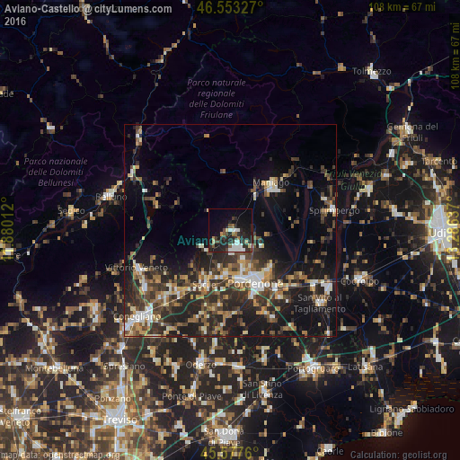
Analysis of Aviano-Castello night lights 2016
Square area 10x10 km:
 3.84%
3.84%90-99
5.54%80-89
2.84%70-79
0.57%60-69
2.27%50-59
3.13%40-49
2.27%30-39
4.4%20-29
15.06%10-19
22.02%0-9
38.07%Square area 50x50 km:
1.88%90-99
2.93%80-89
1.8%70-79
2.15%60-69
2.83%50-59
2.96%40-49
4.13%30-39
4.67%20-29
8.24%10-19
13.54%0-9
54.86%Clear (daylight) street map image can be seen on geolist.org.
Map coordinates:
46° 33' 11.8" North, 11° 52' 48.4" East
46° 4' 3.3" North, 12° 34' 59.7" East
45° 34' 39.4" North, 13° 17' 10.9" East
Some cities around Aviano-Castello sort by population:
• Pordenone
13.7 km =8.5 mi,  154°
154°
• Sacile
14.1 km =8.8 mi,  206°
206°
• Cordenons
13 km =8.1 mi,  135°
135°
• Porcia
11.9 km =7.4 mi,  167°
167°
• Maniago
14.5 km =9 mi,  40°
40°
• Vigonovo-Fontanafredda
9.1 km =5.7 mi,  197°
197°
• Caneva
14.8 km =9.2 mi,  223°
223°
• Roveredo in Piano
7.1 km =4.4 mi,  157°
157°
3179596 (p: 5,465)
Sources (retrieved 2019-11-25):
» Earth at Night: Flat Maps 2012, 2016