San Daniele del Friuli night lights from space
Night Light of San Daniele del Friuli (Friuli Venezia Giulia) from space (Italy) Src. Average luminocity for 10x10km area is 24.6065% and for 50x50km: 16.545%.
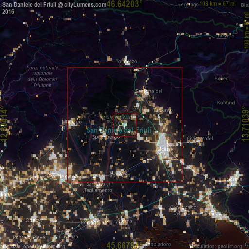
Analysis of San Daniele del Friuli night lights 2016
Square area 10x10 km:
 1.42%
1.42%90-99
3.41%80-89
2.98%70-79
1.28%60-69
3.69%50-59
3.98%40-49
3.55%30-39
5.97%20-29
4.12%10-19
45.88%0-9
23.72%Square area 50x50 km:
1.47%90-99
2.84%80-89
1.5%70-79
1.41%60-69
1.8%50-59
2.6%40-49
2.93%30-39
3.22%20-29
5.37%10-19
17.2%0-9
59.67%Clear (daylight) street map image can be seen on geolist.org.
Map coordinates:
46° 38' 31.3" North, 12° 18' 14.9" East
46° 9' 25.7" North, 13° 0' 26.1" East
45° 40' 4.6" North, 13° 42' 37.4" East
Some cities around San Daniele del Friuli sort by population:
• Tavagnacco
17.4 km =10.8 mi,  107°
107°
• Gemona
15.7 km =9.8 mi,  34°
34°
• Spilimbergo
10.1 km =6.3 mi,  241°
241°
• Tarcento
17.1 km =10.6 mi,  68°
68°
• Buia
10.4 km =6.5 mi,  54°
54°
• Majano
5.4 km =3.4 mi, 51°
• Tricesimo
16.1 km =10 mi,  88°
88°
• Martignacco
12.4 km =7.7 mi,  124°
124°
3168438 (p: 6,700)
Sources (retrieved 2019-11-25):
» Earth at Night: Flat Maps 2012, 2016