Lentate sul Seveso night lights from space
Night Light of Lentate sul Seveso (Lombardy) from space (Italy) Src. Average luminocity for 10x10km area is 90.2273% and for 50x50km: 73.8747%.
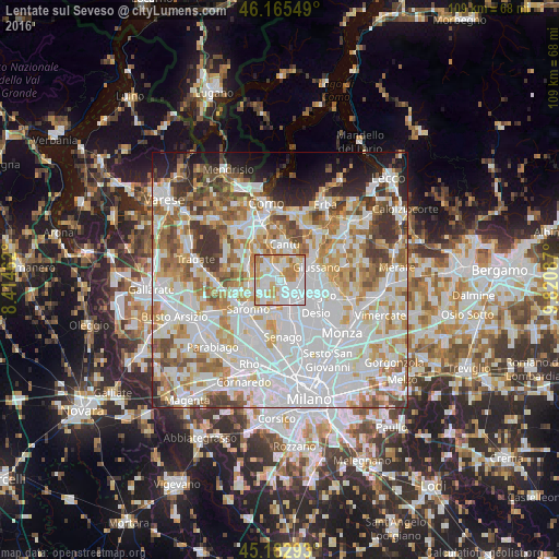
Analysis of Lentate sul Seveso night lights 2016
Square area 10x10 km:
 41.21%
90-99
21.67%80-89
12.42%70-79
14.39%60-69
10.3%50-59
0%40-49
0%30-39
0%20-29
0%10-19
0%0-9
0%Square area 50x50 km:
27.66%90-99
19.19%80-89
7.17%70-79
8.59%60-69
9.07%50-59
6.46%40-49
5.13%30-39
5.08%20-29
3.78%10-19
4.77%0-9
3.09%Clear (daylight) street map image can be seen on geolist.org.
Map coordinates:
46° 9' 55.8" North, 8° 24' 52.6" East
45° 40' 34.9" North, 9° 7' 3.9" East
45° 10' 58.5" North, 9° 49' 15.1" East
Some cities around Lentate sul Seveso sort by population:
• Seveso
3.8 km =2.4 mi,  149°
149°
• Meda
3.2 km =2 mi,  121°
121°
• Cermenate
3.9 km =2.4 mi,  317°
317°
• Cogliate
4.5 km =2.8 mi,  221°
221°
• Lazzate
2.6 km =1.6 mi,  259°
259°
• Cabiate
4.4 km =2.7 mi,  93°
93°
• Barlassina
2.5 km =1.6 mi,  159°
159°
• San Michele-San Giorgio
5.1 km =3.2 mi,  295°
295°
3174888 (p: 10,981)
Sources (retrieved 2019-11-25):
» Earth at Night: Flat Maps 2012, 2016