Barlassina night lights from space
Night Light of Barlassina (Lombardy) from space (Italy) Src. Average luminocity for 10x10km area is 94.2121% and for 50x50km: 76.5263%.
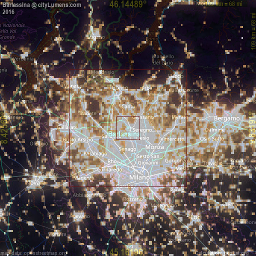
Analysis of Barlassina night lights 2016
Square area 10x10 km:
 55%
55%90-99
22.88%80-89
8.64%70-79
8.79%60-69
4.7%50-59
0%40-49
0%30-39
0%20-29
0%10-19
0%0-9
0%Square area 50x50 km:
29%90-99
19.96%80-89
7.28%70-79
8.8%60-69
9.27%50-59
6.66%40-49
5.51%30-39
5.7%20-29
3.89%10-19
2.88%0-9
1.05%Clear (daylight) street map image can be seen on geolist.org.
Map coordinates:
46° 8' 41.6" North, 8° 25' 32.4" East
45° 39' 20.1" North, 9° 7' 43.6" East
45° 9' 43.1" North, 9° 49' 54.9" East
Some cities around Barlassina sort by population:
• Cesano Maderno
3.4 km =2.1 mi,  148°
148°
• Seveso
1.5 km =0.9 mi,  131°
131°
• Meda
2 km =1.2 mi,  71°
71°
• Lentate sul Seveso
2.5 km =1.6 mi,  339°
339°
• Cogliate
4 km =2.5 mi,  254°
254°
• Lazzate
3.9 km =2.4 mi,  297°
297°
• Cabiate
4.1 km =2.5 mi,  59°
59°
• Ceriano Laghetto
4.8 km =3 mi,  232°
232°
3182341 (p: 6,826)
Sources (retrieved 2019-11-25):
» Earth at Night: Flat Maps 2012, 2016