San Michele-San Giorgio night lights from space
Night Light of San Michele-San Giorgio (Lombardy) from space (Italy) Src. Average luminocity for 10x10km area is 84.7167% and for 50x50km: 69.8763%.
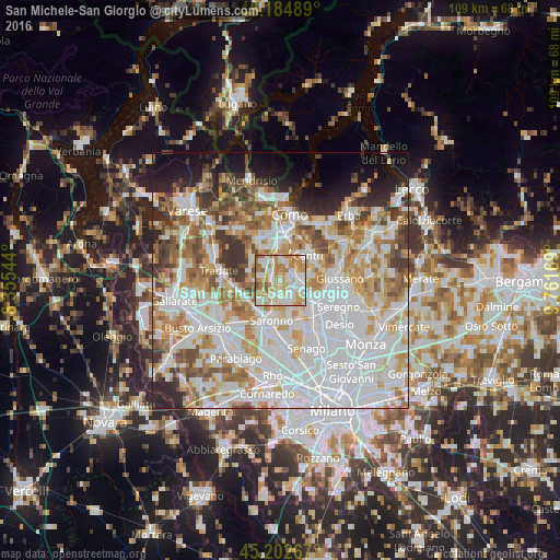
Analysis of San Michele-San Giorgio night lights 2016
Square area 10x10 km:
 22.58%
90-99
25.3%80-89
13.79%70-79
17.27%60-69
16.97%50-59
3.33%40-49
0.76%30-39
0%20-29
0%10-19
0%0-9
0%Square area 50x50 km:
25.44%90-99
17.56%80-89
6.87%70-79
8.25%60-69
9.08%50-59
6.16%40-49
5.16%30-39
4.93%20-29
4.93%10-19
5.86%0-9
5.77%Clear (daylight) street map image can be seen on geolist.org.
Map coordinates:
46° 11' 5.6" North, 8° 21' 19.6" East
45° 41' 45.4" North, 9° 3' 30.8" East
45° 12' 9.6" North, 9° 45' 42.1" East
Some cities around San Michele-San Giorgio sort by population:
• Lentate sul Seveso
5.1 km =3.2 mi,  115°
115°
• Cermenate
2.1 km =1.3 mi,  70°
70°
• Lomazzo
1.9 km =1.2 mi,  272°
272°
• Lazzate
3.3 km =2.1 mi,  143°
143°
• Rovellasca
3.3 km =2.1 mi,  193°
193°
• Cadorago-Caslino al Piano
3.8 km =2.4 mi,  335°
335°
• Guanzate
4.6 km =2.9 mi,  319°
319°
• Bregnano
0.2 km =0.1 mi,  16°
16°
3167969 (p: 5,040)
Sources (retrieved 2019-11-25):
» Earth at Night: Flat Maps 2012, 2016