Cogliate night lights from space
Night Light of Cogliate (Lombardy) from space (Italy) Src. Average luminocity for 10x10km area is 92.1197% and for 50x50km: 76.9766%.
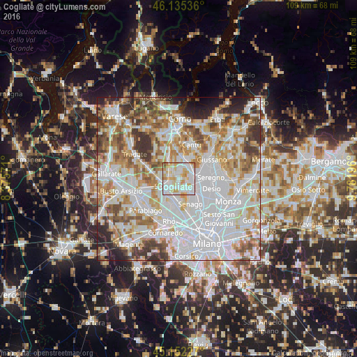
Analysis of Cogliate night lights 2016
Square area 10x10 km:
 38.18%
90-99
29.09%80-89
16.21%70-79
13.03%60-69
2.27%50-59
1.21%40-49
0%30-39
0%20-29
0%10-19
0%0-9
0%Square area 50x50 km:
29.04%90-99
19.93%80-89
7.35%70-79
8.83%60-69
9.55%50-59
6.67%40-49
5.74%30-39
5.85%20-29
4.47%10-19
2.13%0-9
0.43%Clear (daylight) street map image can be seen on geolist.org.
Map coordinates:
46° 8' 7.3" North, 8° 22' 32.6" East
45° 38' 45.5" North, 9° 4' 43.8" East
45° 9' 8.2" North, 9° 46' 55.1" East
Some cities around Cogliate sort by population:
• Saronno
4.1 km =2.5 mi,  235°
235°
• Solaro
3.5 km =2.2 mi,  174°
174°
• Lentate sul Seveso
4.5 km =2.8 mi,  41°
41°
• Lazzate
2.9 km =1.8 mi,  8°
8°
• Rovellasca
3.3 km =2.1 mi,  314°
314°
• Barlassina
4 km =2.5 mi,  74°
74°
• Rovello Porro
3.1 km =1.9 mi,  282°
282°
• Ceriano Laghetto
1.9 km =1.2 mi,  176°
176°
6534937 (p: 8,450)
Sources (retrieved 2019-11-25):
» Earth at Night: Flat Maps 2012, 2016