Umbertide night lights from space
Night Light of Umbertide (Umbria) from space (Italy) Src. Average luminocity for 10x10km area is 10.9879% and for 50x50km: 9.4025%.
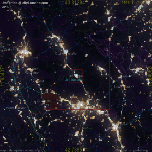
Analysis of Umbertide night lights 2016
Square area 10x10 km:
 1.52%
1.52%90-99
1.97%80-89
1.36%70-79
2.12%60-69
1.36%50-59
0.45%40-49
0.61%30-39
1.82%20-29
0.45%10-19
0.91%0-9
87.42%Square area 50x50 km:
1.03%90-99
1.61%80-89
0.85%70-79
1.04%60-69
1.18%50-59
1.35%40-49
1.8%30-39
1.26%20-29
2.46%10-19
6.14%0-9
81.3%Clear (daylight) street map image can be seen on geolist.org.
Map coordinates:
43° 48' 46.6" North, 11° 38' 3.7" East
43° 18' 12.3" North, 12° 20' 15" East
42° 47' 22.5" North, 13° 2' 26.2" East
Some cities around Umbertide sort by population:
• Perugia
21.7 km =13.5 mi,  168°
168°
• Città di Castello
19.8 km =12.3 mi,  335°
335°
• Gubbio
19.7 km =12.2 mi,  74°
74°
• Chiugiana-La Commenda
22.9 km =14.2 mi,  185°
185°
• Magione
20.7 km =12.9 mi,  209°
209°
• Camucia-Monsigliolo
30.1 km =18.7 mi,  260°
260°
• Castiglione del Lago
31.3 km =19.4 mi,  230°
230°
• bishopric of Perugia
21.6 km =13.4 mi, 168°
3165052 (p: 11,040)
Sources (retrieved 2019-11-25):
» Earth at Night: Flat Maps 2012, 2016