Bastia umbra night lights from space
Night Light of Bastia umbra (Umbria) from space (Italy) Src. Average luminocity for 10x10km area is 37.7333% and for 50x50km: 13.7886%.
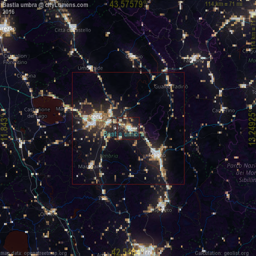
Analysis of Bastia umbra night lights 2016
Square area 10x10 km:
 3.81%
3.81%90-99
7.94%80-89
4.13%70-79
4.44%60-69
1.75%50-59
5.56%40-49
8.73%30-39
4.76%20-29
16.51%10-19
39.68%0-9
2.7%Square area 50x50 km:
1.27%90-99
2%80-89
1.13%70-79
1.66%60-69
1.8%50-59
1.98%40-49
2.86%30-39
1.91%20-29
5.01%10-19
11.67%0-9
68.7%Clear (daylight) street map image can be seen on geolist.org.
Map coordinates:
43° 34' 32.8" North, 11° 50' 34.8" East
43° 3' 51.3" North, 12° 32' 46" East
42° 32' 54.2" North, 13° 14' 57.3" East
Some cities around Bastia umbra sort by population:
• Perugia
13.8 km =8.6 mi,  292°
292°
• Foligno
17.6 km =10.9 mi,  133°
133°
• Chiugiana-La Commenda
19.7 km =12.2 mi,  281°
281°
• Gualdo Tadino
26.3 km =16.3 mi,  45°
45°
• Marsciano
22.5 km =14 mi,  224°
224°
• Santa Maria degli Angeli
2.5 km =1.6 mi,  109°
109°
• Magione
28.5 km =17.7 mi, 287°
• bishopric of Perugia
13.8 km =8.6 mi, 292°
3182289 (p: 17,831)
Sources (retrieved 2019-11-25):
» Earth at Night: Flat Maps 2012, 2016