Guastalla night lights from space
Night Light of Guastalla (Emilia-Romagna) from space (Italy) Src. Average luminocity for 10x10km area is 35.3143% and for 50x50km: 32.6912%.
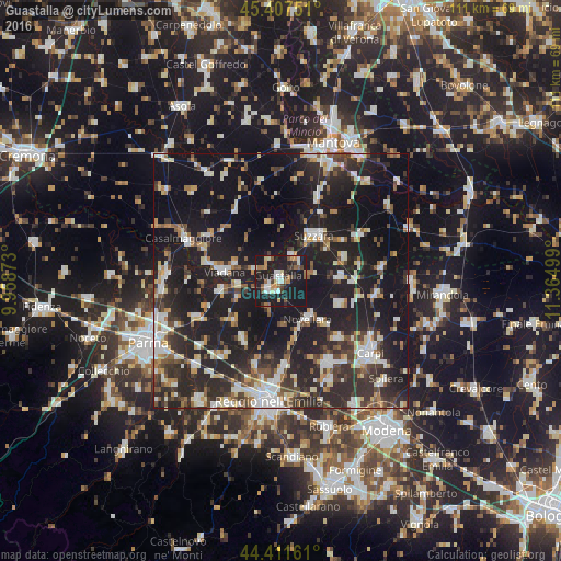
Analysis of Guastalla night lights 2016
Square area 10x10 km:
 4.76%
4.76%90-99
5.87%80-89
3.02%70-79
4.29%60-69
4.76%50-59
5.24%40-49
3.33%30-39
3.17%20-29
9.68%10-19
55.87%0-9
0%Square area 50x50 km:
4.37%90-99
6.36%80-89
2.97%70-79
2.77%60-69
3.2%50-59
3.63%40-49
4.45%30-39
5.86%20-29
15.29%10-19
34.27%0-9
16.83%Clear (daylight) street map image can be seen on geolist.org.
Map coordinates:
45° 24' 27" North, 9° 57' 31.4" East
44° 54' 42.2" North, 10° 39' 42.7" East
44° 24' 41.8" North, 11° 21' 54" East
Some cities around Guastalla sort by population:
• Suzzara
11.1 km =6.9 mi,  35°
35°
• Viadana
11.6 km =7.2 mi,  283°
283°
• Novellara
9.1 km =5.7 mi,  145°
145°
• Castelnovo di Sotto
13.3 km =8.3 mi,  214°
214°
• Reggiolo
11.7 km =7.3 mi,  86°
86°
• Fabbrico
12.4 km =7.7 mi,  110°
110°
• Gonzaga
13.2 km =8.2 mi,  70°
70°
• Boretto
8.8 km =5.5 mi,  262°
262°
3175693 (p: 11,682)
Sources (retrieved 2019-11-25):
» Earth at Night: Flat Maps 2012, 2016