Castelnovo di Sotto night lights from space
Night Light of Castelnovo di Sotto (Emilia-Romagna) from space (Italy) Src. Average luminocity for 10x10km area is 29.2984% and for 50x50km: 38.8886%.
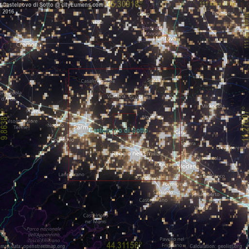
Analysis of Castelnovo di Sotto night lights 2016
Square area 10x10 km:
 2.86%
2.86%90-99
3.65%80-89
2.54%70-79
3.97%60-69
3.02%50-59
3.65%40-49
2.54%30-39
2.54%20-29
17.78%10-19
49.37%0-9
8.1%Square area 50x50 km:
5.81%90-99
7.78%80-89
3.61%70-79
3.58%60-69
4.12%50-59
5.12%40-49
5.91%30-39
8.31%20-29
17.41%10-19
28.87%0-9
9.48%Clear (daylight) street map image can be seen on geolist.org.
Map coordinates:
45° 18' 33" North, 9° 51' 49.7" East
44° 48' 45.1" North, 10° 34' 1" East
44° 18' 41.6" North, 11° 16' 12.3" East
Some cities around Castelnovo di Sotto sort by population:
• Guastalla
13.3 km =8.3 mi,  34°
34°
• Novellara
13.2 km =8.2 mi,  74°
74°
• Cavriago
13.5 km =8.4 mi,  193°
193°
• Sant'Ilario d'Enza
11.2 km =7 mi,  237°
237°
• Bagnolo in Piano
10 km =6.2 mi,  122°
122°
• Sorbolo
10.4 km =6.5 mi,  290°
290°
• Cadelbosco di Sopra
5.8 km =3.6 mi,  154°
154°
• Boretto
10 km =6.2 mi,  352°
352°
3179547 (p: 7,401)
Sources (retrieved 2019-11-25):
» Earth at Night: Flat Maps 2012, 2016