Viadana night lights from space
Night Light of Viadana (Lombardy) from space (Italy) Src. Average luminocity for 10x10km area is 39.1937% and for 50x50km: 32.0394%.
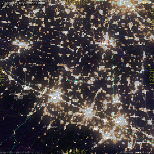
Analysis of Viadana night lights 2016
Square area 10x10 km:
 5.24%
5.24%90-99
7.94%80-89
4.44%70-79
1.27%60-69
6.83%50-59
6.19%40-49
4.13%30-39
2.86%20-29
20%10-19
40%0-9
1.11%Square area 50x50 km:
4.67%90-99
6.39%80-89
2.79%70-79
2.9%60-69
3.15%50-59
3.57%40-49
4.34%30-39
5.76%20-29
14.21%10-19
30.13%0-9
22.09%Clear (daylight) street map image can be seen on geolist.org.
Map coordinates:
45° 25' 52" North, 9° 48' 57.1" East
44° 56' 7.9" North, 10° 31' 8.3" East
44° 26' 8.3" North, 11° 13' 19.6" East
Some cities around Viadana sort by population:
• Suzzara
18.8 km =11.7 mi,  70°
70°
• Guastalla
11.6 km =7.2 mi,  103°
103°
• Casalmaggiore
9.8 km =6.1 mi,  307°
307°
• Novellara
19.3 km =12 mi,  121°
121°
• Castelnovo di Sotto
14.2 km =8.8 mi,  164°
164°
• Sorbolo
11.6 km =7.2 mi,  210°
210°
• Colorno
11.5 km =7.1 mi,  264°
264°
• Boretto
4.6 km =2.9 mi,  145°
145°
3164440 (p: 14,654)
Sources (retrieved 2019-11-25):
» Earth at Night: Flat Maps 2012, 2016