Pedrengo night lights from space
Night Light of Pedrengo (Lombardy) from space (Italy) Src. Average luminocity for 10x10km area is 82.8106% and for 50x50km: 47.017%.
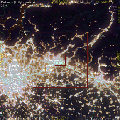
Analysis of Pedrengo night lights 2016
Square area 10x10 km:
 35.3%
35.3%90-99
24.55%80-89
5.76%70-79
6.97%60-69
6.36%50-59
7.42%40-49
6.36%30-39
6.82%20-29
0.45%10-19
0%0-9
0%Square area 50x50 km:
9.38%90-99
10.34%80-89
4.72%70-79
5.45%60-69
7.15%50-59
7.88%40-49
7.28%30-39
7.94%20-29
9.57%10-19
11.57%0-9
18.73%Clear (daylight) street map image can be seen on geolist.org.
Map coordinates:
46° 11' 5.7" North, 9° 1' 54.6" East
45° 41' 45.5" North, 9° 44' 5.8" East
45° 12' 9.8" North, 10° 26' 17.1" East
Some cities around Pedrengo sort by population:
• Seriate
1.4 km =0.9 mi,  213°
213°
• Torre Boldone
3.2 km =2 mi,  318°
318°
• Albano Sant'Alessandro
2.6 km =1.6 mi,  110°
110°
• Gorle
1.7 km =1.1 mi,  289°
289°
• Villa di Serio
3 km =1.9 mi,  0°
0°
• Scanzo-Rosciate
1.6 km =1 mi, 0°
• Ranica
3.5 km =2.2 mi,  331°
331°
• Brusaporto
3.4 km =2.1 mi,  144°
144°
6534499 (p: 5,799)
Sources (retrieved 2019-11-25):
» Earth at Night: Flat Maps 2012, 2016