Gambolò night lights from space
Night Light of Gambolò (Lombardy) from space (Italy) Src. Average luminocity for 10x10km area is 25.4348% and for 50x50km: 27.7976%.
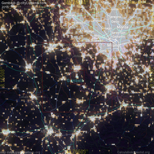
Analysis of Gambolò night lights 2016
Square area 10x10 km:
 3.64%
3.64%90-99
2.27%80-89
1.97%70-79
3.18%60-69
1.82%50-59
3.48%40-49
1.97%30-39
3.48%20-29
11.21%10-19
44.55%0-9
22.42%Square area 50x50 km:
5.45%90-99
5.65%80-89
2.39%70-79
2.81%60-69
2.98%50-59
2.63%40-49
3.28%30-39
4.27%20-29
9.08%10-19
19.68%0-9
41.77%Clear (daylight) street map image can be seen on geolist.org.
Map coordinates:
45° 45' 17.4" North, 8° 9' 18.3" East
45° 15' 43.5" North, 8° 51' 29.5" East
44° 45' 54.1" North, 9° 33' 40.8" East
Some cities around Gambolò sort by population:
• Vigevano
5.8 km =3.6 mi,  357°
357°
• Abbiategrasso
15.8 km =9.8 mi,  16°
16°
• Mortara
9.9 km =6.2 mi,  261°
261°
• Garlasco
9 km =5.6 mi,  145°
145°
• Casorate Primo
13.6 km =8.5 mi,  66°
66°
• Motta Visconti
10.9 km =6.8 mi, 74°
• Cassolnovo
11.6 km =7.2 mi,  341°
341°
• Cilavegna
10.4 km =6.5 mi,  301°
301°
3176333 (p: 7,939)
Sources (retrieved 2019-11-25):
» Earth at Night: Flat Maps 2012, 2016