Cassolnovo night lights from space
Night Light of Cassolnovo (Lombardy) from space (Italy) Src. Average luminocity for 10x10km area is 25.1984% and for 50x50km: 34.9738%.
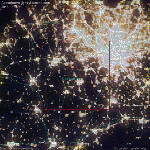
Analysis of Cassolnovo night lights 2016
Square area 10x10 km:
 3.33%
3.33%90-99
3.97%80-89
0.48%70-79
2.38%60-69
3.17%50-59
1.75%40-49
4.13%30-39
1.11%20-29
7.94%10-19
58.73%0-9
13.02%Square area 50x50 km:
8.11%90-99
8.14%80-89
3.06%70-79
3.5%60-69
3.81%50-59
3.33%40-49
3.74%30-39
4.64%20-29
10.35%10-19
16.97%0-9
34.36%Clear (daylight) street map image can be seen on geolist.org.
Map coordinates:
45° 51' 10.6" North, 8° 6' 33" East
45° 21' 39.8" North, 8° 48' 44.3" East
44° 51' 53.5" North, 9° 30' 55.5" East
Some cities around Cassolnovo sort by population:
• Vigevano
6.2 km =3.9 mi,  147°
147°
• Abbiategrasso
9.1 km =5.7 mi,  63°
63°
• Magenta
12.8 km =8 mi,  26°
26°
• Trecate
10 km =6.2 mi,  323°
323°
• Gambolò
11.6 km =7.2 mi,  161°
161°
• Cerano
5.8 km =3.6 mi,  337°
337°
• Cilavegna
7.7 km =4.8 mi,  223°
223°
• Romentino
13.5 km =8.4 mi,  327°
327°
3179778 (p: 6,673)
Sources (retrieved 2019-11-25):
» Earth at Night: Flat Maps 2012, 2016