Casorate Primo night lights from space
Night Light of Casorate Primo (Lombardy) from space (Italy) Src. Average luminocity for 10x10km area is 31.6651% and for 50x50km: 43.1862%.
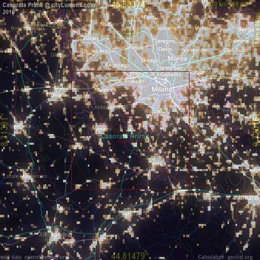
Analysis of Casorate Primo night lights 2016
Square area 10x10 km:
 2.22%
2.22%90-99
5.08%80-89
5.24%70-79
4.29%60-69
4.13%50-59
1.59%40-49
2.38%30-39
2.06%20-29
18.1%10-19
45.56%0-9
9.37%Square area 50x50 km:
13.45%90-99
8.73%80-89
3.94%70-79
3.71%60-69
4.42%50-59
3.58%40-49
4.12%30-39
5.15%20-29
11.77%10-19
21.68%0-9
19.46%Clear (daylight) street map image can be seen on geolist.org.
Map coordinates:
45° 48' 13.5" North, 8° 18' 50.1" East
45° 18' 41.1" North, 9° 1' 1.3" East
44° 48' 53.2" North, 9° 43' 12.6" East
Some cities around Casorate Primo sort by population:
• Vigevano
12.7 km =7.9 mi,  271°
271°
• Abbiategrasso
12.4 km =7.7 mi,  320°
320°
• Motta Visconti
3.3 km =2.1 mi,  216°
216°
• Lacchiarella
9.5 km =5.9 mi,  82°
82°
• Basiglio
12.3 km =7.6 mi,  64°
64°
• Binasco
6.4 km =4 mi,  70°
70°
• Gaggiano
10.5 km =6.5 mi,  7°
7°
• Rosate
4.3 km =2.7 mi,  359°
359°
3179809 (p: 8,424)
Sources (retrieved 2019-11-25):
» Earth at Night: Flat Maps 2012, 2016