Garlasco night lights from space
Night Light of Garlasco (Lombardy) from space (Italy) Src. Average luminocity for 10x10km area is 19.1485% and for 50x50km: 24.5129%.
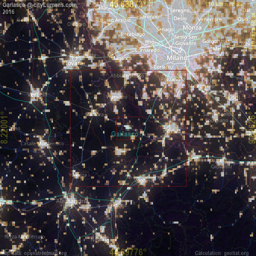
Analysis of Garlasco night lights 2016
Square area 10x10 km:
 1.82%
1.82%90-99
2.27%80-89
1.06%70-79
5.15%60-69
0.61%50-59
2.27%40-49
1.36%30-39
1.67%20-29
4.09%10-19
25.76%0-9
53.94%Square area 50x50 km:
3.32%90-99
3.9%80-89
2.56%70-79
2.63%60-69
3.29%50-59
2.65%40-49
3.09%30-39
3.42%20-29
8.97%10-19
24.28%0-9
41.88%Clear (daylight) street map image can be seen on geolist.org.
Map coordinates:
45° 41' 19.4" North, 8° 13' 12" East
45° 11' 43.4" North, 8° 55' 23.3" East
44° 41' 51.9" North, 9° 37' 34.5" East
Some cities around Garlasco sort by population:
• Pavia
18.5 km =11.5 mi,  91°
91°
• Vigevano
14.3 km =8.9 mi,  337°
337°
• Mortara
16.1 km =10 mi,  291°
291°
• Casorate Primo
14.8 km =9.2 mi,  29°
29°
• Gambolò
9 km =5.6 mi,  325°
325°
• Motta Visconti
11.6 km =7.2 mi, 27°
• Mede
18.3 km =11.4 mi,  233°
233°
• Sannazzaro de' Burgondi
10.4 km =6.5 mi,  187°
187°
3176299 (p: 8,607)
Sources (retrieved 2019-11-25):
» Earth at Night: Flat Maps 2012, 2016