Cilavegna night lights from space
Night Light of Cilavegna (Lombardy) from space (Italy) Src. Average luminocity for 10x10km area is 21.473% and for 50x50km: 26.9199%.
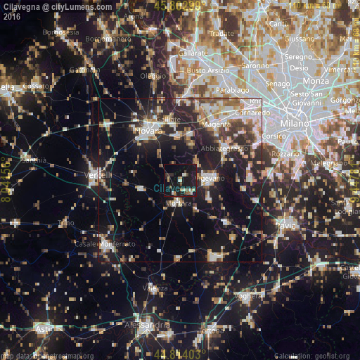
Analysis of Cilavegna night lights 2016
Square area 10x10 km:
 1.59%
1.59%90-99
4.13%80-89
1.27%70-79
1.59%60-69
2.7%50-59
2.22%40-49
2.54%30-39
1.27%20-29
3.49%10-19
45.24%0-9
33.97%Square area 50x50 km:
4.44%90-99
5.5%80-89
2.42%70-79
2.89%60-69
3.3%50-59
2.85%40-49
3.23%30-39
4.02%20-29
8.68%10-19
18.59%0-9
44.1%Clear (daylight) street map image can be seen on geolist.org.
Map coordinates:
45° 48' 10.8" North, 8° 2' 29.6" East
45° 18' 38.4" North, 8° 44' 40.9" East
44° 48' 50.5" North, 9° 26' 52.1" East
Some cities around Cilavegna sort by population:
• Vigevano
8.6 km =5.3 mi,  87°
87°
• Abbiategrasso
16.6 km =10.3 mi,  54°
54°
• Trecate
13.7 km =8.5 mi,  357°
357°
• Mortara
6.9 km =4.3 mi,  187°
187°
• Gambolò
10.4 km =6.5 mi,  121°
121°
• Cassolnovo
7.7 km =4.8 mi,  43°
43°
• Cerano
11.4 km =7.1 mi,  15°
15°
• Robbio
12.1 km =7.5 mi,  258°
258°
3178698 (p: 5,583)
Sources (retrieved 2019-11-25):
» Earth at Night: Flat Maps 2012, 2016