Galatina night lights from space
Night Light of Galatina (Apulia) from space (Italy) Src. Average luminocity for 10x10km area is 47.1867% and for 50x50km: 31.7267%.
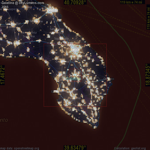
Analysis of Galatina night lights 2016
Square area 10x10 km:
 6.82%
6.82%90-99
9.25%80-89
3.73%70-79
7.47%60-69
6.82%50-59
4.38%40-49
6.66%30-39
10.55%20-29
32.63%10-19
11.69%0-9
0%Square area 50x50 km:
3.53%90-99
6.17%80-89
4.02%70-79
3.44%60-69
4.19%50-59
3.23%40-49
3.34%30-39
6.55%20-29
17.54%10-19
20.95%0-9
27.04%Clear (daylight) street map image can be seen on geolist.org.
Map coordinates:
40° 42' 33.4" North, 17° 28' 1.9" East
40° 10' 27" North, 18° 10' 13.2" East
39° 38' 5.2" North, 18° 52' 24.4" East
Some cities around Galatina sort by population:
• Nardò
11.8 km =7.3 mi,  272°
272°
• Aradeo
6.1 km =3.8 mi,  214°
214°
• Martano
11.6 km =7.2 mi,  74°
74°
• Cutrofiano
6 km =3.7 mi,  152°
152°
• Collepasso
11.5 km =7.1 mi,  183°
183°
• Corigliano d'Otranto
7.5 km =4.7 mi,  102°
102°
• Neviano
8.9 km =5.5 mi, 211°
• Soleto
3.4 km =2.1 mi,  63°
63°
3176407 (p: 19,569)
Sources (retrieved 2019-11-25):
» Earth at Night: Flat Maps 2012, 2016